
Phoenicians and Romans · The Santa Margherita Lines · The Cottonera Lines · Città Cospicua · 1798 and the French · Fort Verdala and Its Prisoners · WWII · Walking Route · Sources · FAQ
Bormla (Cospicua) is the kind of place most visitors walk past on their way to Birgu’s waterfront restaurants or Senglea’s Gardjola viewpoint, and that’s a shame. Sandwiched between those two fortified peninsulas, Bormla is the reason the Three Cities survived as long as they did. It was always the weak spot — the exposed landward flank — and the amount of limestone and money thrown at fixing that vulnerability tells you how much every occupying power cared about holding Malta’s harbours.
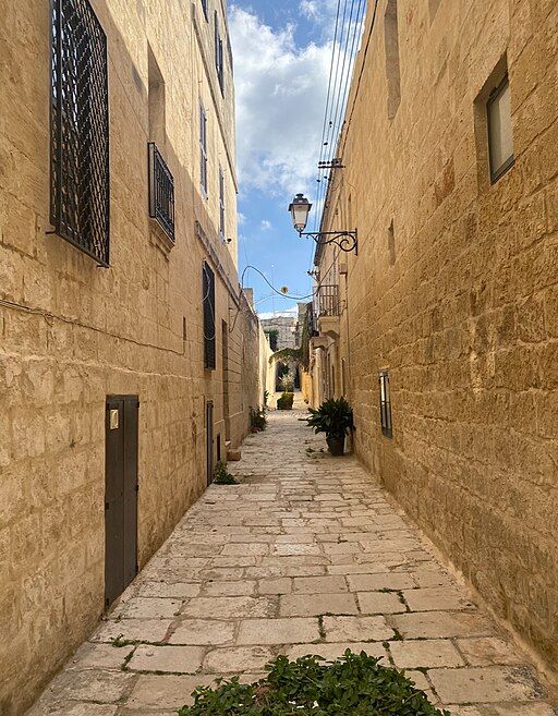
With a population of about 5,100, Bormla is actually the largest of the Three Cities. It doesn’t feel like it when you’re there, because the fortification walls dominate everything. The walls aren’t something you look at from a distance — you live inside them.
I walk through here fairly often and I still spot things I’d missed before — gun loops bricked up by the British, scratched graffiti left by soldiers three hundred years ago, the way it all suddenly makes sense once you’re on top of the bastions looking inland toward the high ground. Most of it is unrestored, overgrown in places, and honestly better for it.
Jaakko.kulta, CC0, via Wikimedia Commons
Phoenicians, Romans, and Why This Harbour Mattered
The name Bormla itself may be the oldest clue. Linguists think it combines the Arabic būr with an older Phoenician root. And the ancient Phoenician name Maleth — meaning “refuge” or “port” — may originally have referred to this harbour before the word migrated to the island as a whole. If that theory holds, the name of the whole country may have started right here on these creeks.
Here’s the basic geography:
- Water on three sides — the deep creeks of the Grand Harbour wrap around Birgu and Senglea, leaving Bormla as the landward hinge between them
- High ground to the south — anyone attacking from inland has the advantage of elevation, which is exactly the problem every later fortification was built to solve
- Continuous habitation — archaeological material from the broader Cottonera area (ceramic fragments, burial sites) confirms people have been living here since well before the medieval period
- No natural defences inland — unlike Birgu and Senglea, which have water protecting their flanks, Bormla’s southern approach is flat and open. That’s why it needed walls.
The Phoenicians were using Malta’s sheltered creeks as stopping points on Mediterranean trade routes by around 700 BC. Later, Roman settlement spread across the harbour area. Physical evidence of Roman-era fortifications near Bormla is thin, but the site’s defensive logic — protected water plus commanding high ground — would not have been lost on Roman engineers.
What the ancients understood by instinct, the Knights of St. John would confirm with bastions, curtain walls, and a hundred years of construction: the land behind Birgu and Senglea was the key to the whole harbour, and everyone who held Malta knew it.
Pygar1954, CC BY-SA 4.0, via Wikimedia Commons
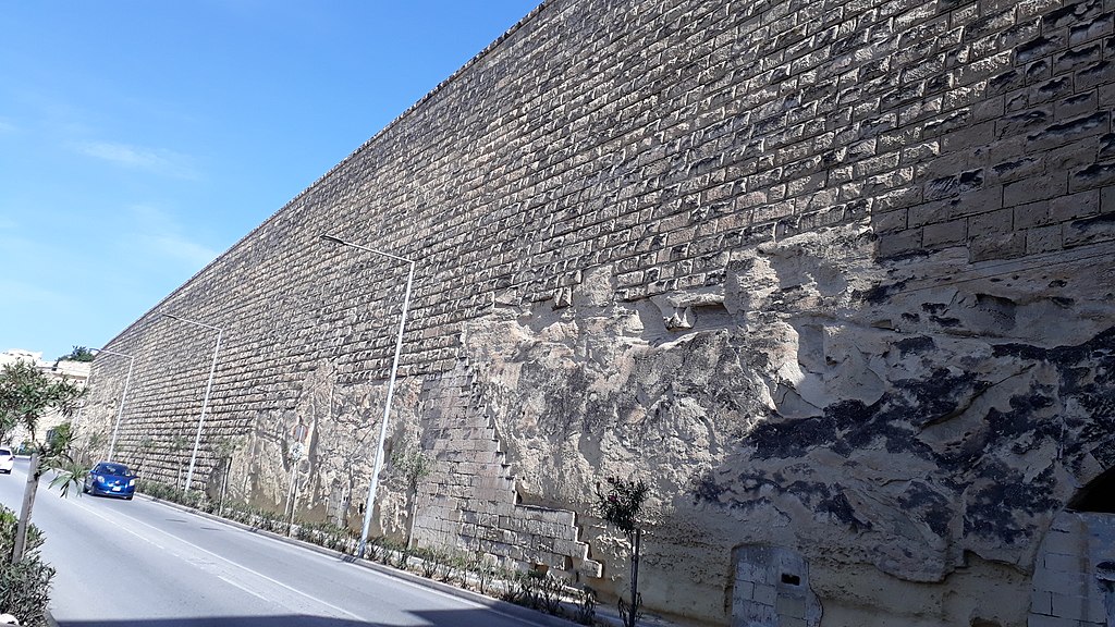
How the Knights Built the Santa Margherita Lines
When the Knights arrived in Malta in 1530, they based themselves in Birgu and quickly spotted the problem. Both Birgu and Senglea (Isla) sit on narrow peninsulas — easy to defend from the sea, but their landward flanks converge on the undefended high ground behind Bormla. During the Great Siege of 1565, the Ottomans hammered exactly this weakness. The experience rattled the Knights badly enough to spend the next two centuries trying to fix it.
On 30 December 1638, Grand Master Giovanni Paolo Lascaris laid the foundation stone for a new line of bastioned fortifications to seal off Bormla’s landward approach. The key details:
- Designer: Fra Vincenzo Maculano da Firenzuola — a Dominican friar who later became a Cardinal. Not just an “engineer” as he’s sometimes described. He also served as a theologian and was one of the inquisitors at Galileo’s trial. His brief was to design a complete bastioned ring (enceinte) that would seal off Bormla and shield the approaches to Birgu and Senglea.
- Problem: Money. By 1645, only three central bastions were finished before funding collapsed entirely
The unfinished works sat there for decades, known as “Fort Margarita,” while the Knights spent their money elsewhere. According to military historian Stephen C. Spiteri — Malta’s leading fortification scholar — construction didn’t restart until 1715, largely because the Order’s engineer René Jacob de Tigné kept pushing for it.
The lines were finally completed in 1736 under the French military engineer Charles François de Mondion, who had a gift for Baroque design (he also built Fort Manoel 📍 across the harbour in Gżira). The finished product:
- 5 bastions and 2 demi-bastions
- 6 curtain walls connecting them
- 3 gateways, at least 2 sally ports
- A ditch, a covertway with lunette, and a glacis
The centrepiece is St. Helen’s Gate (Porta dei Mortari) 📍, Bormla’s main entrance. It’s military Baroque — designed to look good and scare you at the same time. Mondion knew what he was doing.
Pygar1954, CC BY-SA 4.0, via Wikimedia Commons
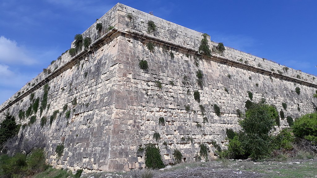
Malta’s Most Ambitious Fortification Project
The Santa Margherita Lines weren’t even finished when the strategic picture changed.
In 1669, the Ottoman Empire captured Candia (modern Heraklion, Crete) after a 21-year siege — the longest in recorded history at that point. The fall of Candia panicked Christian Europe, and Grand Master Nicolas Cotoner concluded that Malta needed a second, much larger defensive ring capable of sheltering the entire harbour-area population.
The new fortifications:
- Designer: Italian military engineer Antonio Maurizio Valperga (who also modified the Floriana Lines and other Grand Harbour defences)
- Named after: Grand Master Cotoner — hence Cottonera Lines
- Scale: Designed to hold up to 40,000 people and their livestock
- Construction began: August 1670
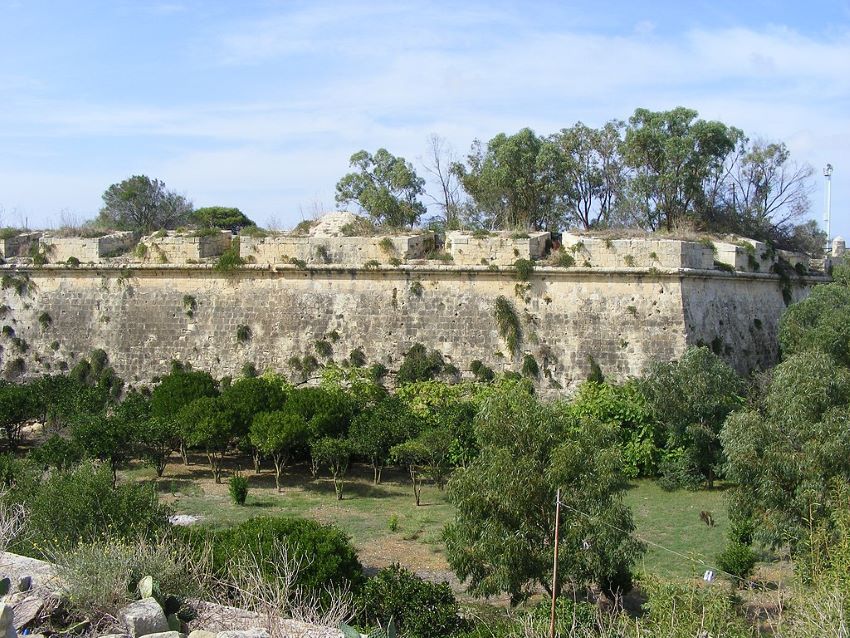
Charles Stephenson, in his Osprey military history of Malta’s fortifications, calls them “the most ambitious work of fortification ever undertaken by the Knights of St John in Malta.” That’s not an exaggeration. Stand on the high ground south of Bormla today and you can trace both rings: the inner Santa Margherita Lines curving tight around the town, the outer Cottonera Lines sweeping in a vast arc across the ridgeline. I’ve not seen anything else quite like it in the Mediterranean, and I’ve looked.
But ambition ran ahead of budget. Again. When Grand Master Cotoner died in 1680, the bastioned walls were mostly up but crucial elements — cavaliers, ravelins, the glacis, the covertway — had never been built. The ditch was left half-dug. The Cottonera Lines were eventually finished in the 1760s, but never to the original specification. The outworks and cavaliers that would have finished the job were simply never built.
More on this period: The Ottoman Empire’s Rise · The Knights After the Great Siege · Fortress Malta: Sieges and Survival
Curtain between Notre Dame Bastion and St. Clement Bastion, Cottonera Lines, Bormla. Pygar1954, CC BY-SA 4.0, via Wikimedia Commons
Bormla Becomes Città Cospicua
With its fortifications finally complete — or as complete as they’d ever be — Bormla got a formal upgrade. In 1722, Grand Master Marc’Antonio Zondadari gave the town the title Città Cospicua (“the Conspicuous City”), a nod to its imposing walls. The name stuck in official documents, though locals still say Bormla.
Two things happened next that shaped the town’s character for the following 250 years:
- 1776 — The Knights built a dockyard in Bormla to service their warships. This was the start of Bormla’s identity as a shipbuilding and dockyard town — a working-class place with grease under its fingernails, quite different from the quieter streets of Birgu or Senglea.
- The Immaculate Conception church 📍 (parish established 1586, current building from the 1630s, rebuilt in Baroque style around 1730) became the heart of the community. The annual festa on 8 December — honouring the Virgin Mary as patron — is still one of the biggest parish celebrations in the harbour area. It’s loud, crowded, and worth seeing if you’re in Malta in early December.
1798 and the French Blockade
When Napoleon’s forces invaded Malta in June 1798, Bormla’s fortifications faced their first actual combat test — and failed without a shot being fired. The gates were opened to the French without resistance. A century of construction and enormous expense, and nobody bothered to defend the result.
Stephen Spiteri has called this deeply ironic, and he’s right. But the story gets more interesting. During the Maltese uprising and French blockade (1798–1800), the fortifications finally saw something close to their intended use — though from the wrong side:
- The French garrison held the Cottonera Lines from inside
- Maltese insurgents built entrenchments around the perimeter
- Makeshift batteries like Tal-Borg Battery and Windmill Redoubt went up in the surrounding countryside
- The French bombarded Maltese positions in Żabbar from behind the walls
It was one of the few times the fortifications saw anything like real military action — and the Maltese were on the outside trying to get in.
More: French Military Tactics in 1798
St. Paul Curtain, Cottonera Lines, Bormla. Pygar1954, CC BY-SA 4.0, via Wikimedia Commons
Fort Verdala and Its Famous Prisoners
When Britain took control of Malta in 1800, the military engineers left the Santa Margherita and Cottonera Lines mostly intact. Their main additions:
- St. Clement’s Retrenchment (1850s) — a new defensive line connecting the two rings, creating a controlled zone between them
- Fort Verdala 📍 (1852–1856) — built by the Royal Engineers directly into the central section of the Santa Margherita Lines, incorporating St. Margherita Bastion and St. Helen Bastion. The fort had a barrack block surrounded by casemated walls and a shallow ditch, initially armed with 24-pounder smooth-bore howitzers (removed in the 1890s when it was converted to barracks)
Fort Verdala’s strangest chapter came during World War I, when it served as a prisoner-of-war camp for captured German and Austro-Hungarian officers. The notable prisoners included:
- Karl von Müller — the celebrated captain of SMS Emden, who had caused havoc raiding British shipping across the Indian Ocean. King George V personally ordered that the Emden‘s captured officers could keep their swords — a gesture of respect for their conduct.
- Franz Joseph, Prince of Hohenzollern-Emden — a member of the German royal family (nephew of the King of Romania, cousin of the Kaiser) who had served aboard the same ship
- Karl Dönitz — a young submarine commander who arrived in October 1918 after his boat, UB-68, was sunk during an attack on a British convoy southeast of Sicily
The Dönitz connection is worth pausing on. He’d actually visited Malta twice before the war as a guest, once in 1912 aboard SMS Breslau. According to accounts from wartime Malta, he used his time as a prisoner to start sketching out the “wolfpack” submarine tactics (Rudeltaktik) that would later devastate Allied shipping in World War II. He eventually ran the entire German submarine war as Grand Admiral, and in May 1945 briefly succeeded Hitler as head of state. Whether the wolfpack idea actually took shape at Verdala or came later is debated, but the connection is there — the man who nearly strangled Britain’s Atlantic supply lines spent months staring at these walls as a prisoner.
More: Malta’s Strategic Role in WWII · How the Three Cities Sustained Malta During WWII
When the Bombs Fell on Bormla
The French never tested the walls. The Luftwaffe did.
The dockyard — expanded massively under British rule and the main base for the Royal Navy in the Mediterranean — made the entire Cottonera area a primary Axis target. Bormla was bombed repeatedly between 1940 and 1943. Before the war, the town had a population of over 12,000. By the time the bombing stopped, it had dropped to under 5,000 as residents fled.
What survived and what didn’t:
- The Collegiate Church of the Immaculate Conception survived — it’s still the centrepiece of the 8 December festa
- Much of the medieval and Baroque streetscape was destroyed — the narrow-lane character you see in Birgu was largely lost in Bormla
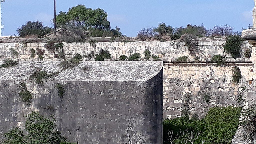
- Parts of the Santa Margherita Lines took hits — the fortifications were designed for 17th-century cannon fire, not aerial bombardment, but the massive limestone walls absorbed punishment that would have flattened anything lighter
- St. Clement’s Bastion got anti-aircraft gun emplacements — a control station and four concrete positions, some of which you can still see today
The dockyard itself became a political flashpoint after independence. At its peak it was one of Malta’s biggest employers, but by the early 2000s the cost of keeping it running accounted for roughly 25% of Malta’s national debt. It was substantially downsized, and plans are now underway to transform parts of the site into a commercial and tourist centre.
More: The WWII Convoys and the Three Cities · Malta’s Strategic Role in WWII
Walk It Yourself — A Step-by-Step Route
None of this is ticketed. No opening hours to worry about (except the Maritime Museum). The fortifications are threaded through the town — roads, houses, laundry lines, cats. That’s what makes the walk good. Here’s the route I’d do, in order, starting from the Valletta ferry.
- Getting there: Take the Valletta–Three Cities ferry (every 30 min, about €2.80 return, 5-minute crossing). The harbour views are half the point. Alternatively, buses 1, 2, 3, 4, or 213 from Valletta take ~15 minutes. From Sliema or Gżira, connect through Valletta. If you’re in my Gżira apartment, the ferry from Valletta is the scenic way.
- Distance: About 3 km as a loop. One uphill stretch to reach the Cottonera Lines.
- Time: 2–2.5 hours at an easy pace, longer if you go inside the museum or church.
- Shoes: Decent ones. Some bastion paths are rough limestone.
- Summer warning: The climb to the Cottonera Lines is fully exposed — no shade at all. In July and August, do this walk before 10 AM or after 4 PM. Bring water. There’s a coffee stop at Dock 1 early in the route — grab a bottle there.
Stop 1 — Ferry Landing at Birgu 📍
The ferry drops you at the Birgu (Vittoriosa) waterfront. Take a minute to look south along the waterline — that’s the direction you’re walking. The walls you can see climbing the hill? That’s where you’re heading.
Stop 2 — Malta Maritime Museum 📍 (~5 min walk)
Walk south along the Birgu waterfront. The Malta Maritime Museum is in the old Royal Naval Bakery (1840s) — right on the water. Check ahead whether it’s open; it’s been under renovation on and off. If it is, worth a quick stop for dockyard context. If not, keep going along the harbour edge toward Bormla.
Stop 3 — Bormla Waterfront and Dock No. 1 ☕ 📍 (~10 min walk)
Cross into Bormla along Dockyard Creek. This is the quiet waterfront — mirror-calm water, a small green park, and the American University of Malta in two restored dockyard buildings (the Knights’ Building from the 1690s and the British Building from the 1840s).
☕ Coffee and water stop. The Dock 1 café is here. Grab a drink and stock up on water — there’s nothing else to buy until you loop back down to the waterfront. Sit facing Senglea and you’ll see why this narrow creek was worth fighting over.

Restored Grand Harbour Dock No. 1, Bormla. Frank Vincentz, CC BY-SA 3.0, via Wikimedia Commons
Stop 4 — Collegiate Church of the Immaculate Conception 📍 (~5 min uphill)
Walk uphill from the waterfront. The Collegiate Church is hard to miss — it’s the biggest building in Bormla. The parish dates from 1586, the current building from the 1630s, rebuilt in Baroque around 1730, and one of the few things that survived WWII bombing. Some serious artwork inside. If you’re in Malta on 8 December, the parish festa here is one of the biggest in the harbour area — fireworks, band marches, packed streets.
Stop 5 — St. Helen’s Gate / Porta dei Mortari 📍 (~5 min walk south)
This is the highlight. Walk south from the church and you’ll hit the main entrance through the Santa Margherita Lines — Mondion’s Baroque gateway, completed 1736. It was built to intimidate and it still does. Walk through it and you’ve crossed into the inner fortification ring. Watch for traffic — cars use the tunnels too, and the reviews confirm they go fast. Don’t linger in the roadway.
Stop 6 — Fort Verdala, exterior 📍 (~10 min along bastions)
From St. Helen’s Gate, follow the bastions toward the Verdala sector. The British Royal Engineers built Fort Verdala (1852–1856) directly into the Santa Margherita Lines, swallowing up older bastions. The casemated walls and ditch are clearly visible from the road. This is where Dönitz was held as a prisoner in 1918. Not open — government housing — but the exterior is the interesting part anyway.
Stop 7 — Cottonera Lines viewpoint 📍 (~10 min uphill — exposed, no shade)
The one proper climb. You’re leaving the inner ring and heading up to the outer Cottonera Lines on the ridge. This section has no shade — in summer, it’s brutal after 11 AM. Pace yourself.
But the payoff is worth it. From up here you can look back and see both rings at once — inner Santa Margherita, outer Cottonera — and the whole double-defence logic finally makes sense. At St. Clement’s Bastion, look for the WWII anti-aircraft gun emplacements: four concrete positions and a control station, bolted onto 17th-century stonework. That clash of centuries in one wall is a good summary of Bormla’s whole story.
St. Nicholas Bastion, Cottonera Lines, Bormla. Pygar1954, CC BY-SA 4.0, via Wikimedia Commons
Stop 8 — Back down to Senglea Waterfront (~15 min downhill)
Head back downhill through Bormla’s streets toward the water. You’re now heading for Senglea — across the pedestrian bridge at the bottom of Dockyard Creek. The waterfront on the Senglea side has a few restaurants with tables right on the water, facing Birgu. Good spot for lunch if you’re hungry.
Stop 9 — Gardjola Gardens, Senglea 📍 (~10 min walk along the peninsula)
The classic Three Cities finish. Gardjola Gardens sit on the tip of the Senglea peninsula — the famous lookout tower carved with an eye and an ear (the sentinel watching the harbour), and views across to Valletta. Honest warning: the gardens have been closed for maintenance more than once in early 2026. Check before you walk out there — a couple of reviews from February and March 2026 confirm closures. If it’s shut, the Senglea waterfront views are still good.
From here, you need to get back to the Birgu ferry terminal (the main ferry runs from Birgu, not Senglea). Two options: walk back along the Senglea waterfront and across the pedestrian bridge to Birgu (~15 min), or grab a traditional dgħajsa water taxi from the Senglea waterfront to Birgu for about €2 — much quicker and a good way to end the day on the water. Full loop done.
More time? Fort St. Angelo 📍 in Birgu (€10, budget 1 hour) is the single best fortification visit in the Three Cities. The Kalkara heritage trail extends the walk east. The Ħal Saflieni Hypogeum 📍 is 2km south in Paola — book ahead, tickets sell out weeks in advance.
Sources and Further Reading
This article draws on the following scholarly and specialist sources. If you want to go deeper into Malta’s military architecture, any of these will pay for themselves:
- Spiteri, Stephen C. (2001). Fortresses of the Knights. Malta: Book Distributors Limited. — The definitive reference on Hospitaller fortification in Malta, by the country’s leading fortification scholar and former Superintendent of Fortifications.
- Spiteri, Stephen C. (2008). The Art of Fortress Building in Hospitaller Malta. Malta: BDL Publications, 597 pp. — Deep study of the military architecture and engineering methods used by the Knights.
- Stephenson, Charles (2004). The Fortifications of Malta 1530–1945. Oxford: Osprey Publishing. — Readable military history covering all periods from the Knights through WWII. Good maps.
- De Lucca, Denis; Spiteri, Stephen C.; Bonnici, Hermann (eds.) (2015). Lines of Defence: Fortification Drawings of the Baroque Age at the National Library of Malta. International Institute for Baroque Studies / Malta Libraries. — Original architectural drawings with expert analysis of how designs evolved.
- Spiteri, Stephen C. (ed.). Arx – Online Journal of Military Architecture and Fortification. Published via MilitaryArchitecture.com. — Peer-reviewed papers on Mediterranean fortification, including detailed work on Cottonera and Santa Margherita elements.
- National Inventory of the Cultural Property of the Maltese Islands — Individual inventory sheets for each bastion, curtain wall, and gateway of both lines, maintained by Heritage Malta (culturalheritage.gov.mt).
Frequently Asked Questions
Can you walk the Bormla fortifications for free?
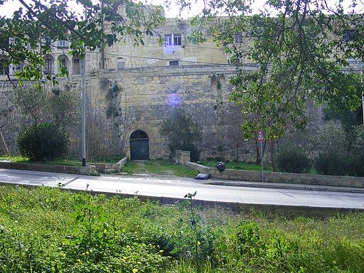
Yes. The Santa Margherita Lines and Cottonera Lines are publicly accessible with no ticket or entry fee. You walk along and through the fortifications as part of the town’s streetscape. Some sections are overgrown or mid-restoration, which adds to the atmosphere. Fort Verdala is the exception — it’s not open to visitors — but you can see the exterior from several points.
What’s the difference between the Santa Margherita Lines and the Cottonera Lines?
Two separate rings. The Santa Margherita Lines (also called the Firenzuola Lines) are the inner ring, built 1638–1736, wrapping tight around Bormla itself. The Cottonera Lines are the outer ring, started 1670 and completed in the 1760s, on higher ground in a much wider arc. Together they form a double-fortification system — rare in Europe and one of the most complete examples in the Mediterranean.
How do I get to Bormla (Cospicua) from Valletta?
By bus: Routes 1, 2, 3, 4, or 213 from Valletta bus station. About 15 minutes. By ferry: The Three Cities ferry from Valletta waterfront runs every 30 minutes and drops you at Birgu, from where Bormla is a short walk. The ferry is the more scenic option.
Is Bormla worth visiting, or should I just do Birgu and Senglea?
Bormla gets far fewer tourists than its neighbours, which is part of the appeal. If military history and fortification architecture interest you, the double ring here is more impressive in scale than anything in Birgu or Senglea. The waterfront and restored dockyard buildings are worth seeing too. Budget 1.5–2 hours to walk the walls properly, or combine with Birgu and Senglea for a full day.
Was Karl Dönitz really a prisoner in Bormla?
Yes. Dönitz was captured in October 1918 when his submarine UB-68 was sunk during an attack on a British convoy southeast of Sicily. He was held at Fort Verdala in Bormla, which served as a WWI officer prisoner-of-war camp. Other notable prisoners included Karl von Müller (captain of SMS Emden) and Franz Joseph, Prince of Hohenzollern-Emden. Dönitz later became Grand Admiral and briefly succeeded Hitler as head of state in May 1945.
Are the fortifications UNESCO World Heritage listed?
Not yet. The Santa Margherita Lines have been on Malta’s tentative UNESCO list since 1998, as part of the broader “Knights’ Fortifications around the Harbours of Malta” nomination. The full listing has not yet been achieved.
What’s the best walking route?
Take the ferry from Valletta to Birgu, walk south along the waterfront into Bormla past the Maritime Museum and Dock No. 1 (grab coffee and water here), uphill to the Collegiate Church, south through St. Helen’s Gate (inner ring), along the bastions to Fort Verdala, uphill to the Cottonera Lines (outer ring — no shade, avoid midday in summer), then back downhill through Bormla to Senglea waterfront and Gardjola Gardens. Ferry back from there. About 3 km as a loop, 2–2.5 hours. Notre Dame Gate is an optional +30 min extension from the Cottonera Lines.
When is the Bormla festa?
8 December each year — the feast of the Immaculate Conception. It’s a major parish celebration with band marches, fireworks, and street decorations. The Collegiate Church is the centre of the festivities. If you’re in Malta in early December, it’s worth timing a visit.
What else is nearby?
The Three Cities are compact enough to cover in a day. From Bormla: the Malta Maritime Museum in Birgu, Gardjola Gardens 📍 in Senglea, Fort St. Angelo 📍, the Kalkara heritage trail, and the Ħal Saflieni Hypogeum 📍 in Paola (about 2km south — book ahead).
Stay in Gżira near the promenade
A designer 2-bedroom apartment in Gżira, close to the church, around 2 minutes from the promenade, and near Manoel Island.
View on Airbnb