The Surprising History of Sliema, Malta
What “Sliema” Actually Means
Before Anyone Built Here
The Great Siege and Dragut’s Death
Fort Tigné
British Rule Changes Everything
The Victorian “Roman Baths”
World War II
The 1950s–60s Golden Era
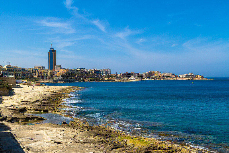
Sliema Today
Walking the History: A Self-Guided Route
Practical Info
FAQ
If you stand on the Sliema promenade on a warm evening, with the Valletta skyline glowing honey-gold across Marsamxett Harbour, it’s hard to believe that 500 years ago an Ottoman army camped on this same ground and one of the most feared corsairs in Mediterranean history died right where the shopping mall now stands. I walk this stretch several times a week, and the layers of history hidden under the apartment blocks and cafés still catch me off guard.
Most Sliema history articles give you either the Wikipedia version or the hotel brochure version. This one covers what actually happened, points out where you can still see the evidence, and tells you what’s worth your time if you’re visiting.
What “Sliema” Actually Means
“Sliema” translates to “peace” or “comfort” in Maltese, but the story behind the name is more specific than most guides tell you. It comes from a small chapel dedicated to Our Lady Star of the Sea (Stella Maris) that once stood on the peninsula, serving as a landmark for fishermen. The chapel’s name connects to the opening words of the Hail Mary prayer in Maltese: “Sliem Għalik Marija.” The fishermen who lived along this rocky shore would have seen the chapel light from their boats, and over time the whole peninsula took its name.
That chapel connection still echoes today. The Stella Maris parish church, built in 1855, remains the spiritual heart of Sliema and a reference point for anyone navigating the town. If you’ve read our brief history of Malta, you’ll know how deeply religion and place-names intertwine on these islands. Our Malta history hub has much more on this.
Before Anyone Built Here
For most of Malta’s recorded history, the Sliema peninsula was close to empty. The land was called il-Qortin, and it had no permanent settlement worth mentioning. A militia watch post existed on what’s now Tigné Point as early as 1417 — just three men keeping an eye on the harbour mouth. There was no church, no harbour infrastructure, nothing to attract settlers. The only thing the peninsula had going for it was its position: it sits directly across Marsamxett Harbour from what would later become Valletta, and anyone controlling these heights could bombard the harbour entrance.
The Knights of St. John, who governed Malta from 1530, understood this vulnerability — and so did the Ottomans, who would exploit that exact position thirty-five years later.
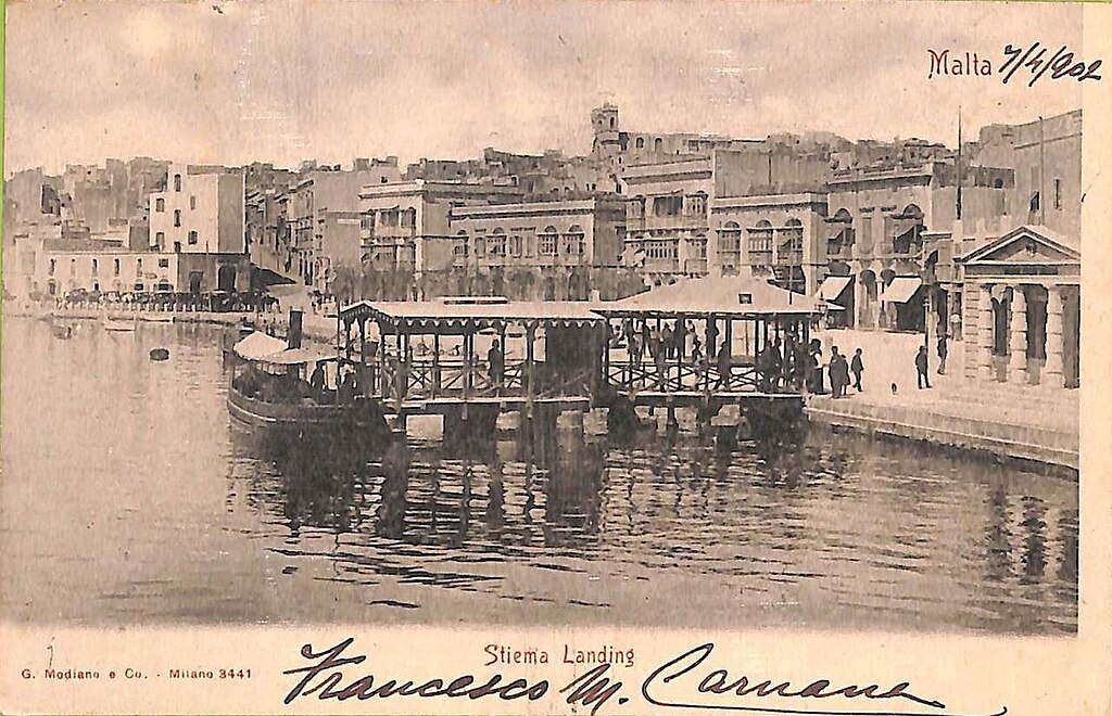
Sliema around 1900. The ferry landing and a handful of buildings — a far cry from the high-rise skyline you’ll see today.
The Great Siege and Dragut’s Death
In May 1565, the Ottoman fleet arrived with somewhere between 30,000 and 40,000 troops to take Malta from the Knights. The area that’s now Sliema became the main Ottoman encampment. If you want the full story, our guide to the Great Siege covers every phase of the battle.
What matters for Sliema’s story is one specific death. Dragut — Turgut Reis in Turkish — was an 80-year-old corsair who had terrorised the Mediterranean for decades. Here’s his track record:
- 1551: Enslaved most of Gozo’s population — roughly 5,000 people
- Appointed Pasha of Tripoli, Bey of Algiers, and Beylerbey of the Mediterranean
- Described by a French admiral as “a living chart of the Mediterranean, skillful enough on land to be compared to the finest generals of the time”
- Sultan Suleiman’s orders stated that Dragut’s commands overrode those of every other Ottoman officer
Dragut set up a battery on the tip of the Sliema peninsula to bombard Fort St. Elmo across the harbour. On or around 18 June 1565, while inspecting his guns and arguing about their firing angle, he was struck — either by debris from his own collapsing trench or by fire from across the water. He died five days later, on 23 June. Historians including Ernle Bradford (in The Great Siege: Malta 1565) and Bruce Ware Allen have argued that Dragut’s death was a turning point: the Ottoman commanders began fighting among themselves, making tactical blunders that eventually led to their retreat in September 1565.
The tip of the peninsula is still called Dragut Point. It’s the exact spot where the Ottoman cannons once stood. Today it’s part of the Tigné Point development, and you can walk there in about ten minutes from the Sliema Ferries. More on the Ottoman Empire’s expansion toward Malta and our article about what happened to the Maltese people during the siege.
Fort Tigné: One of the World’s First Polygonal Forts
After the Great Siege, the Knights knew they needed to fortify Dragut Point. Various proposals were drawn up over the next two centuries — including a whole fortified city in the 1670s — but nothing was built until 1792, when the threat of French invasion finally forced action.
Key facts about Fort Tigné:
- Commissioned by: Grand Master Emmanuel de Rohan-Polduc
- Designed by: Antoine Étienne de Tousard, the Order’s last chief military engineer
- Built: 1793–1795, under capomastro Antonio Cachia
- Named after: The knight François René Jacob de Tigné
- Status: On Malta’s tentative UNESCO World Heritage list since 1998
- Significance: One of the earliest truly polygonal forts in the world
What makes Fort Tigné actually a big deal — not just locally but in military architecture worldwide — is its design. Based on the Lunette d’Arçon and the work of Marc René, marquis de Montalembert, it broke from the star-shaped bastioned designs that had dominated European fortification for 300 years. Dr. Stephen C. Spiteri of the University of Malta has described it as one of the earliest truly polygonal forts in the world. The circular keep with musketry loopholes and the diamond-shaped main body were nothing like what came before. The UNESCO tentative list entry quotes Professor Quentin Hughes, who called Malta’s military architecture “a monumental heritage… for sheer concentration and majesty quite unmatched.”
Fort Tigné was the last major fortification built by the Order. It saw limited action in the French invasion of 1798, where it was one of the few fortifications that actually tried to resist Napoleon’s forces. The British garrisoned it from 1805 until 1979. After the British left, it fell into disrepair for decades before being restored by MIDI plc in 2008. You can visit it freely today. Our Fortress Malta article puts it in context.
British Rule Changes Everything
Malta became part of the British Empire in 1800, and the British turned Sliema from empty scrubland into a proper town within about 50 years. The population began growing noticeably from 1853, and by 1878, there were enough residents to justify declaring Stella Maris Church a separate parish from Birkirkara.
The Military Buildup
The British didn’t just build homes — they fortified the peninsula heavily. Beyond upgrading Fort Tigné, they constructed three major batteries, partly in response to the founding of the Italian Regia Marina in 1861 and the launch of modern Italian battleships in the 1870s:
- Sliema Point Battery (1872–76)
- Cambridge Battery (1878–86)
- Garden Battery (1889–94)
Barrack blocks followed across the rest of the peninsula in the early 1900s. In 1881, the first seawater distillery on the island was built in Sliema to supply the Tigné barracks with drinking water. It was decommissioned just a year later, but the building still stands and has housed a printing press since 1882 — one of Sliema’s most unusual survivors. The barracks it served were demolished in 2001 to make way for the Tigné Point development.
A Summer Resort for Valletta’s Elite
As the 19th century went on, Sliema became the summer retreat of choice for wealthy Valletta residents. They built elegant Victorian villas and townhouses along the coastline and commuted by the Valletta–Sliema ferry. Streets were named after British governors and places:
- Norfolk Street
- Prince of Wales Road
- Windsor Terrace
- Graham Street and Milner Street
- Fort Cambridge
Many of those names survive today, and if you know to look for them, they’re a walking lesson in colonial-era Malta. A distinctive group of six traditional houses with Maltese balconies has survived at Belvedere Terrace, set back from Ix-Xatt (the Strand). These houses overlook Manoel Island across Sliema Creek. They have heritage protection, meaning the lower buildings between them and the waterfront can’t be built upwards — a rare piece of good news in a town that has lost most of its architectural heritage.
Manoel Island
Adjacent to Sliema, Manoel Island played its own role during the British period. The island had been fortified since the 1720s under Grand Master Manoel de Vilhena, and its Lazzaretto served as a quarantine hospital from the 1590s through several plague and cholera outbreaks. Under British control, it functioned as a naval base and was off-limits to the Maltese public for decades. Fort Manoel later appeared in Game of Thrones — it’s the limestone star fort visible from the Sliema waterfront. Our Manoel Island guide covers the full story.
The Victorian “Roman Baths”
One of Sliema’s most photographed features is a series of rectangular rock-cut pools along the northern shoreline, especially concentrated near Fond Għadir and Qui-Si-Sana. Locals and tourist guides call them “Roman Baths,” and the name appears on social media constantly. I’ve seen visitors insist they’re thousands of years old.
They have nothing to do with the Romans, despite the name. Here’s what we actually know:
- They were carved from soft Globigerina limestone during the Victorian era, probably in the second half of the 1800s
- Sea bathing had become fashionable among the British and wealthy Maltese
- The pools were privately owned, cut in square shapes about 1.3 metres deep so people who couldn’t swim could still enjoy the water safely
- Look closely at the corners — you’ll see where wooden posts were planted to hold canvas canopies for shade and privacy
- The area known as Exiles gets its name from Russian émigrés who settled there after the 1917 Bolshevik revolution
Folklorist Arthur Grima noted in the journal L-Imnara (1992) that until the 1930s, “whenever you see a woman at the sea you would have thought that she had fallen in the sea as she would have been fully clothed.” The pools make more sense when you realise they were designed for an era when swimming was a formal, private activity.
A 2007 report by Geotek Services, commissioned by the Sliema Local Council, found that the rock-cut pools are eroding and recommended protective measures. They haven’t been formally scheduled as heritage by the Planning Authority. We’ve written a dedicated piece on the Sliema “Roman Baths” with more detail.
The rocky shore near Fond Għadir, where the Victorian “Roman Baths” are carved into the limestone. Good for swimming and snorkelling when the sea is calm — but watch the swell on windy days.
World War II: Sliema Under Bombardment
Malta’s strategic role in WWII made the entire island a target. Sliema was hit particularly hard:
- In 1941, a single Axis air raid killed 21 civilians in the town
- Bombing continued throughout the Siege of Malta (1940–1943)
- Fort Tigné was damaged by aerial bombardment
- Many of the elegant Victorian buildings that had defined the town’s character were destroyed
Sliema’s residents held on, like the rest of the island — Malta was awarded the George Cross in 1942 for collective bravery. But the physical cost was enormous. When reconstruction came after the war, it brought a different architectural vision. Traditional Maltese houses and surviving Victorian villas found themselves standing next to modern apartment blocks. That mix — sometimes jarring, sometimes oddly charming — is what you see when you walk through Sliema’s inner streets today.
The 1950s and 1960s: Sliema’s Golden Era
The mid-20th century was a special time for Sliema. The town became where young Malta came to hang out — drawn by its beaches, entertainment venues, and the general postwar mood that things were looking up.
The place everyone remembers from this era was The Chalet — an open-air dance pavilion built on the water near what is now Fond Għadir. Live bands played, dances were held under the stars, and a generation of Maltese grew up with The Chalet as the centre of their social world. Ask anyone over 65 about The Chalet and you’ll get a long, fond answer. The beaches — especially Fond Għadir — were packed in summer, and Sliema’s reputation as the place to go in summer was locked in.
This was also the era when the development machine really got moving. The Victorian villas along Tower Road began disappearing one by one, replaced by the apartment blocks that now define the skyline. By the 1970s and 80s, the town was unrecognisably taller and noisier than what the old Slimizi families remembered. Whether that counts as progress depends on who you ask. A town called “Peace” shouldn’t need double-glazing to sleep at night, but here we are.
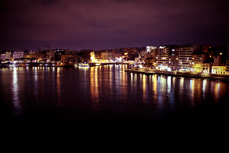
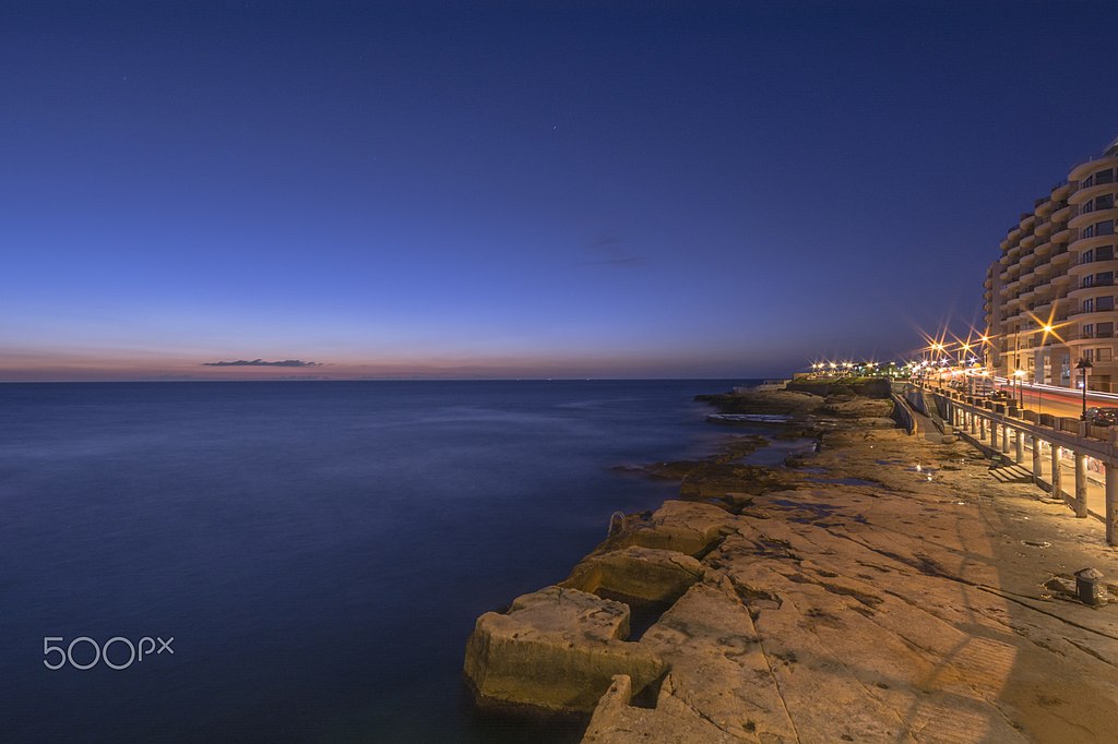
The Sliema promenade after dark. This is the stretch where The Chalet once stood — now apartment blocks, but the energy on a summer evening is still something. Photo: Malcolm Debono.
Sliema Today
Modern Sliema is Malta’s most densely populated town. Some quick numbers:
- Population: ~23,000 residents
- Coastline: 3.5 km, with swimming access along most of it
- Promenade: ~5 km, connecting Gżira to St. Julian’s
- Property prices: Among the highest in Malta
Shopping and Daily Life
The Point Shopping Mall — Malta’s largest — opened in 2010 on the site of the former Tigné Barracks. Parts of Pjazza Tigné still contain original barrack arches integrated into the modern design. Bisazza Street and Tower Road are the main shopping and dining strips. Independence Garden, a green space on the seafront, offers benches, fountains, and a sculpture by Matthew Pandolfino — plus a small cat village where stray cats are sheltered and fed.
Remote Workers and Digital Nomads
Sliema has become one of Malta’s main bases for remote workers. Reliable internet, co-working spaces, a walkable town, and an international community mean it works if you need to get things done and still want a life outside your laptop. The iGaming industry has a heavy presence here, which feeds the café culture and international restaurant scene. Our remote work guide covers the logistics.
Water Sports
The clear water around Sliema is excellent for scuba diving, with several dive schools operating from the town. The rocky coastline is good for snorkelling year-round, and there are access points all along the promenade — our beach map shows every swimming spot on the island. Our wreck diving guide covers dive sites accessible from Sliema. Beyond the water, Malta has solid rock climbing and mountain biking — neither is based in Sliema, but both are a short bus ride away.
Food, Wine, and Culture
You can eat your way around the world without leaving Sliema — Maltese, Italian, Asian, Middle Eastern — there’s more restaurant variety per square metre here than anywhere else on the island. Wine bars serve local varieties including Girgentina and Gellewza alongside international labels. Our Maltese wine guide is worth reading before you go.
The Salesian Theatre (Teatru Salesjan), in Sliema’s backstreets, has been running for over a century. It was restored and reopened as one of Malta’s cultural reference points, hosting music, plays, and contemporary art. The proscenium features a wall painting called The Virtues of Mankind by Maltese artist Giuseppe Calì. There’s also a café inside — a good spot for coffee that most tourists walk right past.
Parish Feasts
Sliema has four parish feasts held in summer, each with its own band club:
- Our Lady of the Sacred Heart — July
- Our Lady of Mount Carmel — July
- Our Lady Stella Maris — August (Stella Maris Band Club, founded 1914)
- St. Gregory the Great — September
If you’re in Malta during summer, I’d say the Sliema feasts are among the best — less chaotic than some village festas but with the same fireworks, band marches, and street food. Check our Malta Village Festas 2026 page for dates.
One of the swimming spots along Tower Road. The water is ridiculously clear for a town this urban — that’s the Globigerina limestone doing its filtering work. Photo: Cezary Borysiuk.
Sliema Wanderers and Other Surprises
A few things about Sliema that most travel guides skip:
- Sliema Wanderers F.C. — one of Malta’s most successful football clubs, with 26 league titles
- Sliema Aquatic Sports Club — dominates water polo with 32 league wins since 1912
- 1st Sliema Scout Group — founded in 1909 by Sir Edgar Bernard, it’s the oldest surviving scout group outside the United Kingdom
- Famous residents: former PM Alfred Sant, rock vocalist Marc Storace (Swiss band Krokus), British journalist Peter Hitchens, and Maltese-American actor Joseph Calleia
- Nine English language schools currently operate in the town — making Sliema one of the largest English-teaching hubs in the Mediterranean
Walking the History: A Self-Guided Route Through Sliema
Most of Sliema’s history is still visible if you know where to look. This route follows the peninsula from the harbour side around the tip and back along the open-sea coast — no backtracking. It covers roughly 4 km with about 3–4 hours of comfortable walking including stops, a coffee break, and lunch.
Practical notes before you start:
- Best day: Any day works. Weekday mornings are quieter. Avoid Sunday if you want the Salesian Theatre café (it closes at 1 PM).
- Shoes: Trainers or sturdy sandals. The promenade is smooth, but the rocky coastline around Fond Għadir will punish flip-flops.
- Bring: Water, sunscreen, swimwear (you’ll want to swim at the “Roman Baths”). A hat in summer.
- Start time: 9:00–9:30 AM works well. You’ll beat the heat and catch Stella Maris Church open.
📍 Open in Google Maps
Time: 9:00 AM | Allow: 5 minutes
What to look for: This is where the Valletta–Sliema ferry has been running since the British era. The views of Valletta’s bastions from the landing are among the best in Malta. If you’re arriving from Valletta, you’ve just done the cheapest harbour cruise available — €1.50 one way. Orient yourself: Manoel Island is to your left, the Strand stretches ahead of you toward Tigné Point.
📍 Open in Google Maps | ManicMalta guide
Time: ~9:05 AM | Allow: 20–30 minutes
What to look for: Cross the bridge from the Strand onto the island. The Lazzaretto quarantine buildings are immediately visible — this island was quarantining plague victims before most European cities had a plan for it. Fort Manoel (1720s) is the star-shaped fortress you can see from outside; interior access is restricted during restoration, but the exterior and ramparts are worth the walk. The island has a slightly wild, abandoned feel that’s unlike anywhere else this close to central Sliema. Note: The park section closes in the evening, so go in the morning.
Time: ~9:35 AM | Allow: 10 minutes (walking + looking)
What to look for: Head west along Ix-Xatt (the Strand), which runs along the harbour side. About halfway toward Tigné, look for Belvedere Terrace — a row of six heritage-protected traditional houses with Maltese balconies, set back from the road. This is the best surviving example of what Sliema’s waterfront once looked like before the apartment blocks arrived. The houses overlook Sliema Creek toward Manoel Island.
📍 Open in Google Maps
Time: ~9:45 AM | Allow: 10–15 minutes
What to look for: Turn slightly inland up Triq il-Kbira (the main street). This is the church that gave Sliema its name, built in 1855. The baroque interior features red columns and sashes and a fresco above the altar. Small but full of character. Opening hours: Generally open mornings and during services; if the main door is locked, try the side entrance. Free entry.
📍 Open in Google Maps | ManicMalta guide
Time: ~10:00 AM | Allow: 20–30 minutes
What to look for: Continue west to the tip of the peninsula. Fort Tigné is the restored 1793 polygonal fort — look for the circular keep, the diamond-shaped main structure, the British gun emplacements added later, and the commemorative plaque above the main gate (worth reading — it names the knight the fort honours). Walk to the very tip (Dragut Point) and look across to Fort St. Elmo — this is the exact geometry of the 1565 siege. The fort is freely accessible and open, though interiors may be locked. The landscaped gardens and walkways around it are pleasant.
📍 Open in Google Maps
Time: ~10:30 AM | Allow: 20–30 minutes
Built on the site of the former Tigné Barracks (demolished 2001), Malta’s largest mall opened in 2010. Look for the surviving barrack arches in Pjazza Tigné — they’re integrated into the modern design. Several cafés on the ground floor. Open daily 10 AM–7:30 PM. There’s also a love-lock bridge on the pedestrian bridge connecting Tigné Point to the rest of Sliema — Malta’s version of Paris’s Pont des Arts. Air conditioning and bathrooms here if you need them.
From the coffee stop, walk around the tip of the peninsula to Tower Road, which runs along the open-sea (north) coast. You’re now heading east.
📍 Open in Google Maps
Time: ~11:15 AM | Allow: 10–15 minutes
What to look for: A shaded green space on the seafront — one of the few quiet spots on this peninsula. The Pandolfino sculpture is here. There’s a children’s playground and, unexpectedly, a small cat village where volunteers care for Sliema’s stray cats. Open 24 hours, free. Good benches, sea view, and a gelateria across the street.
📍 Open in Google Maps
Time: ~11:30 AM | Allow: 10–15 minutes
What to look for: A short detour inland on Triq Guze’ Howard. Running for over 100 years, this is Sliema’s oldest theatre. The restored interior features Giuseppe Calì’s wall painting The Virtues of Mankind on the proscenium. There’s a café inside that most tourists walk right past — good coffee, relaxed atmosphere. Café open Mon–Sat 9 AM–3 PM, Sun 8 AM–1 PM. If there’s a performance listed, consider coming back in the evening.
📍 Open in Google Maps | ManicMalta guide
Time: ~11:45 AM | Allow: 20–40 minutes (longer if you swim)
What to look for: Continue east along Tower Road. Fond Għadir beach has the biggest cluster of the Victorian rock-cut pools. Look for:
- The carved steps leading into each pool
- Corner post-holes where wooden canopy frames once stood
- The contrast between the shallow square pools (private Victorian baths) and the natural rock
- Salt pans from an earlier period, visible as smaller depressions
Swimming: The pools are usable when the sea is calm. Avoid on windy days — waves crest the walls. No lifeguard specifically for the baths, though the beach has a lifeguard in summer. Bring water shoes — the rocks are uneven and can be sharp.
📍 Open in Google Maps
Time: ~12:30 PM | Allow: 45–60 minutes
Right at Fond Għadir, directly overlooking the “Roman Baths.” Outdoor terrace on the water. Good for burgers, seafood, and an English breakfast that runs all day. Not the cheapest spot on the promenade, but the location is unbeatable — you’re eating lunch above Victorian swimming pools with the open Mediterranean in front of you. Open daily from 8:30 AM. Budget: €15–25 per person for a main and a drink. If Surfside is too busy, there are several other cafés within a 2-minute walk along Tower Road.
After lunch, you have two options:
Sliema at sunrise, looking east along the promenade. If you’re an early riser, this is worth setting an alarm for. Photo: Wikimedia Commons.
Practical Information for Visitors
From Malta International Airport, Sliema is about 20 minutes by car or app-based ride (Bolt, eCabs — expect €18–22). Buses run frequently but take longer. Once you’re on the island, the Valletta–Sliema ferry runs every 30 minutes and is one of the best cheap thrills in Malta — our How to Get to Malta page covers all the options. Sliema itself is walkable, with the promenade connecting most points of interest. If you need to go further afield, read our guide to renting a car in Malta before committing — parking in Sliema is a real pain.
Where to stay: Sliema has hotels at every price point, from five-star properties to self-catering apartments. These guides will help:
- Where to Stay in Malta — neighbourhood-by-neighbourhood breakdown
- Hotel vs Airbnb in Malta — honest comparison
- Holiday Rental Guide — what to check before booking
- Airbnb Alternatives in Malta — platforms most visitors don’t know about
Weather-wise, spring (April–June) and autumn (September–November) are the sweet spot — comfortable temperatures, fewer crowds, and lower prices. Summer is hot but coincides with parish feasts and the full social calendar. Winter is mild compared to northern Europe but expect some wet, windy weeks — check our weather by month page for specifics. For day trips, our 20 day trips from Sliema and Gżira covers everything within reach by bus, ferry, or short drive. And if you’re still deciding whether Malta is right for your trip, the Malta travel guide and Is Malta Right for You? are the places to start.
Frequently Asked Questions
What does “Sliema” mean in Maltese?
Sliema (Tas-Sliema) means “peace” or “comfort.” The name comes from a chapel dedicated to Our Lady Star of the Sea (Stella Maris) that served as a landmark for fishermen. It’s linked to the opening of the Hail Mary prayer in Maltese: “Sliem Għalik Marija.” The parish church bearing the same name was built in 1855 and is still a central feature of the town.
Are the “Roman Baths” in Sliema actually Roman?
No. Despite the popular name, the rock-cut pools along Sliema’s northern shoreline were carved during the Victorian era (mid-to-late 1800s) when sea bathing became fashionable among the British and wealthy Maltese. They were privately owned and designed for people who couldn’t swim to enjoy the sea safely. Malta does have genuine Roman archaeological sites, but these are not among them.
Can you visit Fort Tigné?
Yes. Fort Tigné was restored in 2008 and is freely accessible at Tigné Point, about a 15-minute walk from Sliema Ferries. You can walk around the restored fort and see its unusual circular keep, the diamond-shaped main body, a commemorative plaque from the 1790s, and gun emplacements the British added in the 19th century. It’s on Malta’s tentative UNESCO World Heritage list as part of the Knights’ harbour fortifications.
What is Dragut Point in Sliema?
Dragut Point is the tip of the Tigné peninsula where the Ottoman corsair Dragut (Turgut Reis) set up his guns to bombard Fort St. Elmo during the Great Siege of 1565. He was fatally wounded there and died on 23 June 1565. His death weakened Ottoman command and contributed to their eventual defeat. The site is now part of the Tigné Point development.
Is Sliema a good base for exploring Malta?
For most visitors, yes. Good bus connections, the Valletta ferry, plenty of accommodation options, and restaurants and shops everywhere you look. It’s walkable, lively, and central. The downsides are traffic, limited parking, construction noise, and the fact that it’s Malta’s most urban area — you won’t get a traditional village feel. If you prefer quieter surroundings, consider the Three Cities or Valletta instead.
When are the Sliema parish feasts?
Sliema has four feasts: Our Lady of the Sacred Heart and Our Lady of Mount Carmel in July, Our Lady Stella Maris in August, and St. Gregory the Great in September. They feature band marches, fireworks, street decorations, and food stalls. Dates shift slightly each year.
What outdoor activities are available from Sliema?
Swimming, snorkelling, and scuba diving directly from the coast. Harbour cruises and the Valletta ferry from Sliema Ferries. Beyond the town, Malta has excellent rock climbing, mountain biking, and beaches across the island.
How do I get from Valletta to Sliema?
The quickest and most enjoyable way is the Marsamxett ferry, which runs every 30 minutes and takes about 10 minutes. It drops you at Sliema Ferries with views of Valletta’s bastions the whole way. Buses and app-based rides (Bolt, eCabs) also connect the two.
If you’re planning to explore Malta’s deeper history, the interactive Malta history timeline is a good place to start connecting the dots between what happened in Sliema and the rest of the island’s story. And for the full cultural events calendar, check what’s on during your visit — Sliema’s location makes it easy to get to almost anything on the island.
Stay in Gżira near the promenade
A designer 2-bedroom apartment in Gżira, close to the church, around 2 minutes from the promenade, and near Manoel Island.
View on Airbnb