
The Complete Guide to Filfla Island
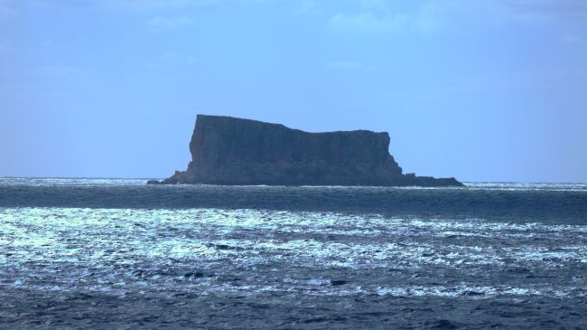
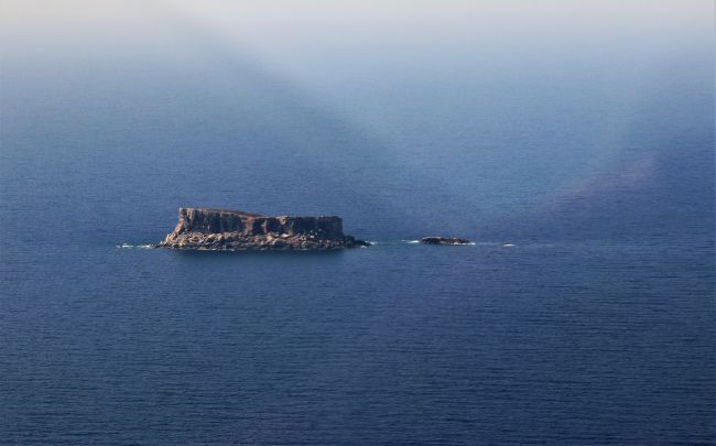
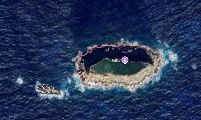
Filfla, a tiny limestone fortress rising from the Mediterranean 4.5 kilometers south of Malta, represents far more than its modest 3.7-hectare size suggests. This crumbling, cliff-ringed islet serves as Malta’s southernmost territorial point and harbors one of the Mediterranean’s most significant seabird colonies.
Quick Facts About Filfla
| Feature | Detail |
|---|---|
| Location | 4.5 km south of Malta |
| Coordinates | 35°47’8.99″N, 14°24’22.19″E |
| Size | 3.7 hectares (37,282 m²) |
| Highest Point | 60 meters above sea level |
| Coastline | 988 meters |
| Population | Uninhabited |
| Access | Strictly prohibited (nature reserve) |
| Status | Malta’s southernmost point |
The Island’s Geological Story
Formation Timeline
- 7-5 million years ago: Upper Coralline Limestone forms during Messinian age
- Pliocene epoch: Separation from Malta via Maghlaq Fault system
- Present day: Continuous erosion shapes dramatic 60-meter cliffs
Key Geological Features
- Rock Type: Upper Coralline Limestone (youngest in Malta)
- Thickness: Approximately 140 meters
- Hardness: Hardest rock layer in Maltese geology
- Color: Pale-grey limestone
- Formation: Part of Malta’s “layer-cake” geological sequence
The Truth About Separation
Despite local legends of catastrophic earthquakes, Filfla separated from Malta through gradual geological processes:
- The Maghlaq Fault system caused a “downthrow” effect
- Displacement exceeded 210 meters
- Part of the larger Pantelleria-Linosa-Malta Graben rift system
- Created contrasting geology visible today
5,000 Years of Sacred History
Timeline of Human Connection
| Period | Significance |
|---|---|
| 4100-2500 BCE | Temple Period pottery and artifacts found |
| Bronze Age | Cart ruts visible until late 1800s |
| 1343 CE | Chapel built inside cave |
| 1604 | Altarpiece created for chapel |
| 1789-1798 | Historical maps reference the chapel |
| 1856 | Earthquake destroys chapel |
| 1880s-1971 | British military bombing range |
| 1980 | Declared bird reserve |
| 1988 | Full nature reserve protection |
Neolithic Temple Connection
The megalithic temples of Ħaġar Qim and Mnajdra were strategically built with direct views of Filfla:
- Built between 3600-2500 BCE
- UNESCO World Heritage sites
- Positioned for astronomical alignment
- Suggest Filfla as cosmological focal point
- Intersection of sea, earth, and sky significance
Medieval Religious Site
The 1343 chapel dedicated to Stella Maris (Star of the Sea) served multiple purposes:
- Shelter: Refuge for fishermen during storms
- Pilgrimage: Spiritual landmark for seafarers
- Art: Housed precious 1604 altarpiece
- Community: Connected to mainland religious life
CopyRight WikiMedia Mika500
Military Target Era (1880s-1971)
Types of Military Use
- Naval bombardment practice
- Live depth charge dropping
- Rocket firing from RAF Hal Far
- Training intensified during WWII
- Part of Malta’s strategic Mediterranean role
Lasting Environmental Impact
| Problem | Current Status |
|---|---|
| Unexploded ordnance | Hundreds of shells in shallow waters |
| Habitat damage | Permanent alteration of landscape |
| Salvaging dangers | Fatal accidents from TNT extraction |
| Fishing restrictions | Safety zones still enforced |
| Cleanup status | Never conducted underwater clearance |
Wildlife Paradise: Endemic Species and Seabird Colonies
Two Species Found Nowhere Else on Earth
Filfla Wall Lizard (Podarcis filfolensis filfolensis)
- First described: 1876
- Appearance: Blackish with bluish spots
- Size: Largest of four Maltese subspecies
- Threats: Gull predation, habitat loss
- Status: Endemic to Filfla only
Filfla Door Snail (Lampedusa imitatrix gattoi)
- Size: Maximum 14 millimeters
- Habitat: Rock crevices
- IUCN Status: Endangered
- Distribution: Extremely limited
- Threats: Environmental changes
Mediterranean Seabird Haven
| Species | Breeding Pairs | Significance |
|---|---|---|
| European Storm Petrel | 5,000-8,000 | 50% of Mediterranean subspecies |
| Cory’s Shearwater | ~200 | Regional importance |
| Yellow-legged Gull | ~130 | Predator species |
Conservation Challenges
- Microplastics: Found in 45% of storm petrel samples
- Climate change: Affecting breeding success
- Erosion: Threatening nesting habitats
- Predation: Gulls prey on lizards and petrel eggs
- Storm damage: Increasing cliff instability
The Name and Its Legends
Etymology Journey
- Arabic origin: “Filfel” meaning pepper
- Medieval maps: “Piper” (Latinized version)
- 16th century: Simply called “Pepper” island
- Modern: Filfla in Maltese
The Maqluba Legend
According to Maltese folklore:
- November 23, 1343: God punished sinful hamlet
- Earth swallowed the village whole
- Angels cast fragment into the sea
- Fragment became Filfla island
- Il-Maqluba sinkhole remains on Malta
Other Myths and Stories
- Pirates used it as hideout
- Home to mysterious sea creatures
- Sacred to prehistoric peoples
- Cursed by military bombing
- Protected by supernatural forces
Legal Landmark: International Maritime Law
The 1985 Libya/Malta Case
| Aspect | Detail |
|---|---|
| Court | International Court of Justice |
| Issue | Continental shelf delimitation |
| Malta’s claim | Include Filfla in baseline calculations |
| Court’s decision | Exclude Filfla as “disproportionate” |
| Vote | 14-3 in favor |
| Impact | Boundary moved 18 minutes latitude north |
Legal Precedent Set on Islets
Small uninhabited islets can be excluded (or given reduced effect) in maritime boundary delimitation.
- “Equitable” considerations can override strict geography.
- Explanation: International law, particularly in maritime delimitation, aims for an “equitable solution” – a fair and just outcome for all parties involved. While geography is the starting point (the physical coastline and features), the Court can adjust the boundary line if a strict geographical application would lead to an inequitable or unreasonable result. In the Filfla case, the geographical fact was Filfla’s existence. However, the equitable consideration was that giving this tiny islet full effect would disproportionately benefit Malta to Libya’s detriment in a way that wasn’t justified by Filfla’s minor geographical significance.
- In simpler terms: Fairness can be more important than just drawing lines based on every single piece of land. If a strict map-based rule leads to a really unfair division, the court can look for a more balanced solution.
- Disproportionate effects caused by minor geographical features must be avoided.
- Explanation: This is closely linked to the idea of equity. The ICJ looks at whether using a particular geographical feature (like Filfla) as a basepoint would create an effect on the boundary line that is out of proportion to the feature’s actual size, importance, or location. In this case, the Court found that the small, uninhabited islet of Filfla would have a disproportionately large effect on the location of the maritime boundary if used as a primary basepoint, swinging the line significantly southwards.
- In simpler terms: A tiny island shouldn’t be allowed to cause a massive shift in the maritime border if that shift seems way too big compared to the island’s actual size or importance. The outcome needs to make sense in proportion.
- The case became significant for international maritime boundaries.
- Explanation: The Libya/Malta judgment, particularly its reasoning regarding Filfla, became an important reference point (a precedent) in international law. Future maritime boundary disputes between other countries often look back at how the ICJ handled Filfla. It helped establish and reinforce the principle that small, uninhabited islands might not always be given full effect in delimitation, especially when it leads to inequitable results or disproportionate effects. It influences how lawyers and states approach similar situations worldwide.
- In simpler terms: This court case wasn’t just about Malta and Libya. It set an important example that other countries and legal experts now use when they have similar arguments about how to divide up sea areas where small islands are involved.
- In essence, the ICJ’s decision regarding Filfla highlighted that while islands generally generate maritime entitlements, very small, uninhabited features might be discounted or given less weight if their inclusion would lead to an unfair or distorted boundary line that doesn’t achieve an equitable result between the states involved.
Malta’s Conservation Commitment
Protection Measures
Legal Framework
- 1980: Bird reserve designation
- 1988: Filfla Natural Reserve Act
- 2010: Marine Protected Area status
- EU: Natura 2000 site
- International: Important Bird Area
Access Restrictions
- General public: Completely prohibited
- Scientists: Special permits required
- Enforcement: Multi-agency cooperation
- Penalties: Substantial fines for violations
- Marine zone: No fishing within protected area
Why Filfla Matters to Malta
| Significance | Impact |
|---|---|
| Territorial extent | Defines southern maritime boundary |
| Conservation symbol | Shows environmental commitment |
| Scientific value | Unique research opportunities |
| Cultural heritage | Part of national identity |
| International status | Global conservation importance |
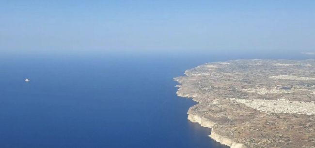
Visiting Filfla: What You Need to Know
Viewing Locations
Since landing is prohibited, you can see Filfla from:
- Dingli Cliffs
- Best panoramic views
- Clear day visibility
- Parking available
- Walking paths
- Blue Grotto area
- Closer maritime views
- Boat trip opportunities
- Tourist facilities
- Photography spots
- Ħaġar Qim temples
- Historical perspective
- Ancient alignment views
- UNESCO site visit
- Visitor center
Best Times to View
- Morning: Clearest visibility
- Spring/Autumn: Best weather conditions
- After rain: Atmospheric clarity
- Sunset: Dramatic lighting
Conservation Success Story
Achievements Since Protection
| Indicator | Result |
|---|---|
| Storm petrel population | Stable/increasing |
| Endemic species | Still present |
| Illegal access | Dramatically reduced |
| Scientific knowledge | Greatly expanded |
| International recognition | Multiple designations |
Ongoing Research
- Seabird population monitoring
- Climate change impacts
- Endemic species genetics
- Marine ecosystem health
- Archaeological investigations
Fun Facts About Filfla
- Movie appearance: Featured in 1980 film “Popeye” as Scab Island
- Historical emblem: Appeared on Malta’s emblem from 1975-1988 (not current coat of arms)
- Twin island: Tiny Filfoletta lies 101 meters southwest
- Age record: Some storm petrels over 32 years old
- Channel name: Waters called Il-Fliegu ta’ Filfla
- Buried governor: Sir Walter Congreve buried at sea nearby
- Wild leek present: Allium ampeloprasum grows on the island despite harsh conditions
The Future of Filfla
Conservation Priorities
- Maintain strict protection
- Monitor climate impacts
- Research endemic species
- Clear remaining ordnance
- Enhance marine protection
Challenges Ahead
- Rising sea levels
- Increasing storms
- Marine pollution
- Tourism pressure
- Resource limitations
Hope for Tomorrow
Filfla demonstrates that even the smallest spaces can have enormous conservation value. Its transformation from bombing target to pristine nature reserve shows humanity’s capacity for positive change and Malta’s commitment to protecting its natural heritage for future generations.
Conclusion
Filfla embodies the Mediterranean paradox: a seemingly insignificant rock that contains multitudes of history, biology, and meaning. This tiny island maintains its secrets while serving as a beacon for scientific research and environmental protection. For Malta, Filfla represents the possibility that even the smallest nations can make substantial contributions to global conservation, protecting spaces where endemic species evolve and international migrations converge in the heart of the Mediterranean Sea.
Stay in Gżira near the promenade

A designer 2-bedroom apartment in Gżira, close to the church, around 2 minutes from the promenade, and near Manoel Island.
View on Airbnb
