
Manoel Island Is Malta’s Most Surprising Walk
What You’ll Find Today · How to Get There · Walking the Island · Game of Thrones and Film Locations · The Black Knight Ghost · Honest Warnings · Fort Manoel and the Knights · The Lazzaretto · WWII Submarine Base · The French Invasion · The Island’s Many Names · FAQ · Returning to the Public
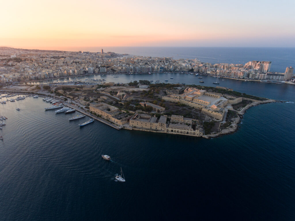
Most visitors to Malta walk right past Manoel Island without realising it’s there. You cross the bridge from Gżira, see some crumbling stone walls, maybe a few cats, and think it’s just another construction site. I grew up here, and even I took it for granted for years before I really looked at it properly.
This small leaf-shaped island — roughly 0.3 square kilometres — packs more history per square metre than almost anywhere else I know:
- A quarantine hospital from the 1640s that processed every ship arriving in Malta for two centuries
- A star-shaped fortress that European military commentators rated among the best anywhere
- A submarine base that helped starve Rommel’s supply lines during WWII
- The spot where Ned Stark lost his head in Game of Thrones
- The centre of a public campaign that gathered over 29,000 signatures and pushed the Maltese government to commit to turning the whole place into a national park
For anyone planning a trip to Malta, Manoel Island is free, easy to reach on foot, and worth a morning of your time. Below: the practical details, the walking route, and then the full history for anyone who wants to go deeper.
What You’ll Find on Manoel Island Today
Let me be honest about what to expect, because online reviews of Manoel Island range from “wonderful hidden spot” to “complete waste of time” — and both are partly right.
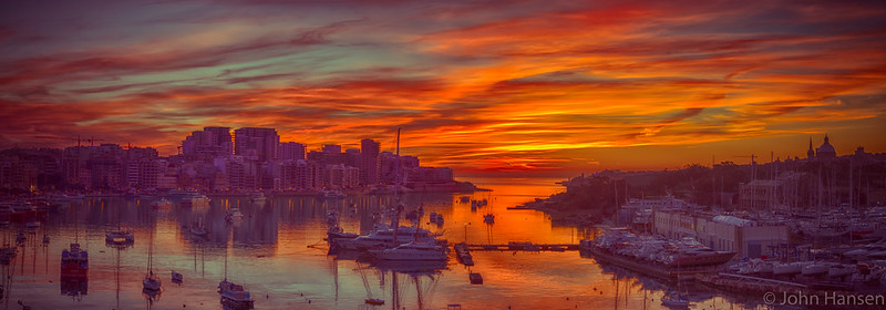
The island is open to the public from sunrise to sunset. You can walk the marked coastal path around most of the shoreline, swim off the rocks on the south and west sides, and get some of the best views of Valletta’s skyline you’ll find anywhere along the harbour. On warm evenings, locals bring disposable barbecues and sit on the rocks with friends — it’s one of those Gżira traditions that tourists rarely stumble into. In July and August, fireworks for the Gżira and Sliema village feasts are launched from the island — watching them from the Sliema waterfront is something I look forward to every year.
What you cannot reliably do is enter Fort Manoel itself. The fort opens occasionally for special events, guided tours, and film productions (most recently Gladiator 2 was shot here), but there’s no regular visiting schedule. The Lazzaretto building is also not open for casual visits. Much of the island’s interior is still fenced off and looks like an abandoned building site. There are no toilets, no cafés, and one vending machine if you’re lucky.
But the raw, unfinished quality is exactly what makes the place interesting. The ruins, the cats, the boats pulled up on shore, the street art on crumbling walls — it all has a kind of rough beauty that somewhere like the Valletta museums or Fort St. Elmo can’t give you. Enjoy it in this state.
How to Get There
From Gżira: Walk along the Strand (the harbourfront promenade) towards Sliema and you’ll see the footbridge on your left. Cross it, and you’re on Manoel Island. The whole walk from central Gżira takes about five minutes.
From Sliema: Roughly 15–20 minutes along the waterfront, passing through Gżira.
Driving: You can park on the initial stretch of Manoel Island itself, just past the bridge — it’s usually much easier to find a spot here than in central Gżira, where street parking is a nightmare. There’s no formal car park — you’re parking on open ground alongside the access road. No cars are allowed past the entrance barrier, so park near the bridge and walk from there.
From Valletta: Take the Sliema ferry from Marsamxett and walk south along the Sliema waterfront, or catch any bus towards Sliema/Gżira (routes 13, 14, 21 from Valletta). The island sits directly across the harbour from the Upper Barrakka Gardens — you can actually see Fort Manoel clearly from there, and many visitors photograph it from that angle without ever visiting. There’s no entrance fee, no ticket office — you just walk across the bridge and you’re there.
Walking the Island: A Loop Around Manoel Island
Take the clockwise loop — it’s the route most locals use, and it puts the best views and key landmarks in the right order. The full loop is about 1.5 km and takes 45–60 minutes at a relaxed pace, or 2 hours if you swim, photograph everything, and spend time at the fort. It’s flat — no hills to speak of. Wear trainers or sturdy sandals (the limestone gets rough in places) and bring water and sunscreen. There is nothing to buy on the island.
Before You Start: Coffee in Gżira
Get fuel before you cross, because there’s nothing on the other side. Brillace Cafe on Triq il-Gzira does proper espresso and homemade cakes — opens 6:30 AM weekdays, 7:30 Sundays. 📍 Google Maps. Or try Loaf on Vjal De La Salle for croissants. 📍 Google Maps
Stop 1: Cross the Bridge and Yacht Marina (5 min)
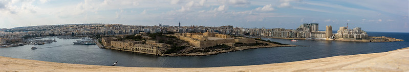
From the Gżira waterfront, the bridge is signposted — you can’t miss it. The island gate is open from sunrise to sunset (it closes at dusk and there’s a watchman). Once across, you’ll see the yacht marina on your left (southeast side of the island, facing Lazzaretto Creek). The marina holds 220 berths and can take vessels up to 100 metres, so you might see some serious boats. Keep walking past it along the access road heading west. 📍 Google Maps
Stop 2: The Lazzaretto and Bovile Route — South Shore (10 min)
As you follow the south shore path, the Lazzaretto complex appears on your right — a row of stone buildings stretching along the water. 📍 Google Maps
You’re looking at the 1643 quarantine hospital where every ship arriving in Malta was processed for over two centuries. The oldest surviving structure is the two-storey Palazzo Vecchio (also called Palazzo Grande). You can’t go inside, but the exterior is well preserved and you can spot historical graffiti on the walls — some carved by quarantined sailors, the earliest dated 1681, the most recent 1947.
The path you’re walking roughly follows the old Bovile route — the track along which quarantined livestock was driven from the waterfront to the Cattle Shed, the oldest standing building on the island. One surviving section of the original Bovile wall is still visible.
Look for: The high perimeter wall that surrounds the complex. It wasn’t decorative — it was built to stop quarantined people from escaping. There were originally six cemeteries in the Lazzaretto grounds. Only one survives.
Across the water to your left: that’s Valletta, with the dome of the Carmelite Church and St. Paul’s Cathedral on the skyline. Morning light hits this view perfectly.
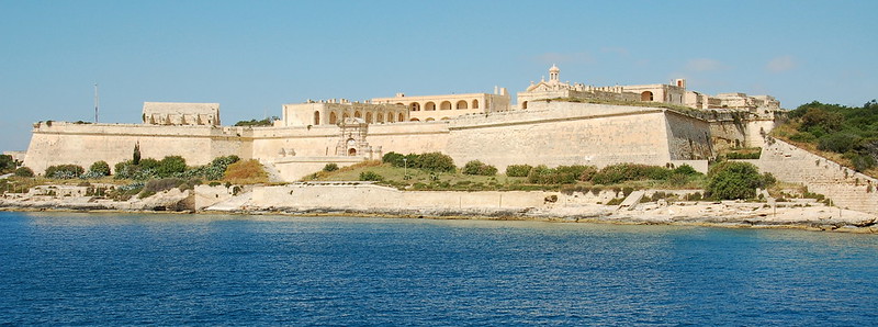
Stop 3: Fort Manoel — The Great Sept of Baelor (15–30 min)
Continue west along the path and you’ll reach Fort Manoel — the star-shaped fortress that dominates the western end of the island. Walk around the outside of the walls and you’ll see the bastions (St. Helen, St. Anthony, St. John, Notre Dame), the ravelin, the glacis, and the restored main gate. 📍 Google Maps
If the fort is open (check the events calendar — open days happen roughly once a month): go inside. The piazza is where Game of Thrones was filmed — you’re standing on the steps of the Great Sept of Baelor from Season 1, Episode 9, the spot where Ned Stark was executed. The reconstructed Chapel of St. Anthony is also inside (the original was destroyed by a Luftwaffe bomb in March 1942). And somewhere beneath your feet is the crypt where Mondion is buried — along with, allegedly, the Black Knight. On some open days, the Legio X Fretensis Malta reenactment group puts on Roman military displays with audience participation — worth catching if the timing lines up.
If the fort is closed (which is most days): you can still peer through the gates at the piazza, and the exterior walk around the walls is worth doing on its own. The Game of Thrones scene was filmed inside the piazza, so what you see through the gates is the actual set. The fort is also regularly used for film productions — Gladiator 2 shot here recently, and visitors have been turned away during filming of Gladiator, Helen of Troy, and Agora over the years.
For GoT fans specifically: Fort Manoel was King’s Landing’s Great Sept of Baelor. Ned’s confession and beheading (S1E9), Joffrey making Sansa look at the heads on spikes (S1E10), and possibly Arya’s first run-in with Hot Pie and Lommy were all filmed here. The two domes visible in the background of the execution scene were CGI — based on San Francisco’s Palace of Fine Arts. Other Malta GoT locations include Fort St. Angelo (Red Keep dungeons), Mdina (King’s Landing gates), and Gozo’s former Azure Window (the Dothraki wedding).
Stop 4: Swimming Rocks and the X127 Wreck — South and West of the Fort (as long as you like)
Below the fort walls on the south and west sides, flat limestone shelving drops into clear water. This is where Gżira locals come to swim — it’s quieter and cleaner than the Sliema front, and the fort walls behind you make a ridiculous backdrop. There’s no sandy beach, no lifeguard, no shade, and no facilities of any kind. Bring water shoes unless your feet are already toughened up on Maltese rock. See our map of beaches in Malta for other options around the island.
For divers: The X127 wreck (also called the Carolita or Coralita) sits just offshore at the start of Lazzaretto Creek — bow at 5 metres, stern at 22 metres. It’s a WWI-era landing craft from the Gallipoli campaign, sunk here in 1942 while fuelling the 10th Submarine Flotilla. One of Malta’s few shallow wreck dives, accessible from the shore. The Malta shipwreck diving guide and scuba diving primer cover the details.
Stop 5: North Shore and Woodland — The Future National Park (15 min)
Round the northwest tip of the island and head back east along the north shore, which faces Sliema Creek. This side is scruffier and wilder — overgrown paths, abandoned boat sheds, scruffy woodland. It’s also the part of the island that the national park campaign is most focused on turning into green public space. The area is the only significant tree cover in this part of Malta — in a neighbourhood where open space is measured in square metres, not acres.
The cats live here. Manoel Island’s feral cat colony hangs out in the northern woodland and around the old boat sheds. They’re friendly and used to people. If you want to feed them, bring actual cat food — not scraps — and take your rubbish with you.
Somewhere along the north shore you can also find a Lord Byron inscription carved into the rock — a reminder that the island has attracted curious visitors for a long time.
Stop 6: Back to the Bridge
The path loops you back to the bridge where you started. Total distance: about 1.5 km. If you swam and explored the fort, you’ve probably been on the island for about 2 hours.
Detailed Map of Manoel Island
This community-built map marks over 50 features on the island — every building, ruin, chapel, battery, cemetery, dive site, and swimming spot. It’s more detailed than anything I could fit in this article.
- Island loop: about 1.5 km, 1–2 hours with swimming and photos
- Access: Open sunrise to sunset. The gate closes at dusk.
- Shoes: Trainers or sturdy sandals. The limestone rock will wreck flip-flops.
- Best day: Weekday mornings — the island is busier with locals on weekends (not bad, but less peaceful). Skip it if it’s been raining — the rock paths get slippery.
- Best time: Late afternoon into sunset if you want the best photos. The Valletta skyline turns gold from the south shore.
- Fireworks: In July and August, fireworks for the Gżira and Sliema village feasts are launched from Manoel Island. Best watched from the Sliema waterfront.
- Water: Bring at least a litre. Nothing to buy on Manoel Island. Nearest shops are back in Gżira, five minutes from the bridge.
- Parking: You can park on the initial stretch of Manoel Island past the bridge — usually easier than finding a spot in Gżira. No cars allowed past the entrance barrier.
- Combine with: A walk along the Sliema waterfront, the “Roman” Baths, the Sliema-Valletta ferry, or the Valletta museums — all reachable on foot from here.
- Where to stay: Gżira or Sliema put you within walking distance.
Game of Thrones and Film Locations
Malta was the original filming location for King’s Landing in Game of Thrones Season 1, before production moved to Dubrovnik. Fort Manoel’s piazza doubled as the Great Sept of Baelor — where Ned Stark was executed in Episode 9 (“Baelor”) and where Joffrey forced Sansa to see the heads on spikes in Episode 10. That scene was when most viewers realised nobody in Westeros was safe.
The two dome structures visible in the background of the execution scene were not real — they were added with CGI, based on San Francisco’s Palace of Fine Arts.
Beyond GoT, the Malta Film Commission continues to lease Fort Manoel for productions. Gladiator 2 was the most recent major shoot — several visitors in 2024 and 2025 found the fort closed because Ridley Scott’s crew had taken over the piazza. The fort has also appeared in Gladiator (the original), Helen of Troy, and Agora. If the fort is closed and there’s equipment visible inside the gates, filming is probably the reason.
Other Game of Thrones locations in Malta include Fort St. Angelo in Birgu (Red Keep dungeons), Mdina (King’s Landing gates), San Anton Gardens (Red Keep exterior), and Gozo’s former Azure Window (the Dothraki wedding, now collapsed). Several operators offer dedicated GoT walking tours.
The Black Knight of Manoel Island
Every good Maltese fort needs a ghost story, and Manoel Island’s is a strange one. The Black Knight of Manoel Island is said to be an apparition in full Knights’ armour and regalia — some accounts describe him as resembling Grand Master de Vilhena himself. The first sightings date to the 1940s, after wartime bombing destroyed the Chapel of St. Anthony. Both Maltese locals and British servicemen reported seeing the figure near the chapel ruins, usually around dusk.
The connection seems to be with the crypt beneath the chapel where Mondion and other knights were buried. When the crypt was opened at some point, the burial had been vandalised and bones scattered. After the remains were reburied, reports of the Black Knight stopped. Then in 1980, the crypt was vandalised again — and the sightings came back. The legend says the knight will keep appearing whenever the bones of the crypt are disturbed. Whether you believe any of that or not, I’ll say this: go stand at the fort walls at dusk, with Valletta’s lights flickering across the harbour, and tell me it doesn’t feel a bit odd. Malta has more of these stories than you’d expect — the legends and myths of Malta article collects the best of them.
Honest Warnings
A few things I wish someone had told me before my first visit:
The fort is usually closed. Don’t go to Manoel Island expecting to tour Fort Manoel. Interior access is limited to occasional open days, guided tours, and event bookings — and sometimes it’s locked up for film shoots. Check before you go. If the fort is closed, the island is still worth visiting for the walk and the views — but manage your expectations.
There are no facilities. No toilets, no café, no water fountain. Bring a bottle of water, especially in summer. The nearest shops and cafés are back in Gżira, about five minutes’ walk from the bridge.
Parts of the island are dangerous. Some of the abandoned buildings are not safe — collapsing floors and unstable walls. Stay on the marked paths and don’t explore ruins. You’re unlikely to have any trouble with other people (you always need to be smart, though), but watch where you put your feet. Fenced-off areas, construction materials, and unfinished paths are part of the current reality too. It’s not polished in the way Fort St. Elmo or the Valletta museums are. If that bothers you, stick to the coastal path and enjoy the sea views.
If you want to know more about safety in Malta generally, or you’re still deciding whether Malta is right for you, those guides give an honest picture.
Fort Manoel and the Knights of St. John (1723–1733)
The real building started with the Knights of St. John. When they arrived in Malta, Valletta’s Grand Harbour was heavily fortified with structures like Fort St. Elmo and Fort St. Angelo, but Marsamxett Harbour on the opposite side of the Valletta peninsula remained wide open. Military engineers had been pointing this out since 1569, when Francesco Collignon first proposed building defences on the island.
It took another 150 years of proposals, revised proposals, committee debates, and bureaucratic delays before anything happened. The key proposals came from:
- 1569 — Francesco Collignon proposed a small fort with a cavalier
- 1577 — Spanish engineer Scipione Campi highlighted the same vulnerability
- 1582 — Giovanni Battista made another case for fortification
- 1670 — Italian engineer Antonio Maurizio Valperga proposed a roughly hexagonal fort in the Dutch style
- 1723 — Grand Master António Manoel de Vilhena finally commissioned construction
The original plans came from military engineer René Jacob de Tigné, later modified by his colleague Charles François de Mondion — who cared about the project enough to be buried in a crypt beneath the fort’s chapel after his death in 1733.
The fort is a textbook piece of Baroque military architecture, drawing on the fortification ideas of the French engineer Sébastien Le Prestre de Vauban. What you’d see inside, when it’s open:
- Four bastions — St. Helen, St. Anthony, St. John, and Notre Dame — covering all approaches
- A parade ground and quadrangle that became the subject of the earliest known photographs of Malta (more on that below)
- Barracks and gunpowder magazines
- The Chapel of St. Anthony of Padua, which gave the fortress a spiritual centre alongside its military purpose
By 1761, Fort Manoel was considered one of the finest completed fortifications in the Mediterranean. The French military commentator Comte de Bourlamaque reportedly called it a “modèle de fortification fait avec soin” — a model of fortification, made with care. Fort Manoel has been on Malta’s tentative list for UNESCO World Heritage status since 1998, as part of the Knights’ fortification system around the harbours. The economics of the Knights explain how the Order funded projects like this across Malta.
For more on the mysteries and legends of the Knights, or their modern-day mission and activities, those articles fill in the wider story. And if you want to walk the full Knights’ trail, the Knights of Malta tour guide maps it out.
The Lazzaretto: Malta’s Quarantine Hospital (1643)
Before Fort Manoel existed, the island’s most important building was the Lazzaretto — a quarantine hospital built to protect Malta from plague and cholera carried by ships arriving in the harbour.
The first version was thrown up in 1592 during a plague outbreak: a collection of wooden huts, torn down a year later when the disease subsided. Not exactly forward-thinking. In 1643, Grand Master Lascaris struck a deal — swapping the island with the Church for land in Rabat — and built a permanent stone Lazzaretto. This made Manoel Island the first stop for anyone arriving in Malta by sea for the next two centuries. The process went roughly like this:
- Ships arriving in Marsamxett Harbour were inspected before passengers could go ashore
- Anyone suspected of carrying disease was brought ashore to the Lazzaretto and isolated
- During the British colonial period (from 1800), the hospital was expanded in the 1830s under Governor Sir Henry Bouverie
- Incoming mail was fumigated at the Profumo Office to stop the spread of disease — think of it as 19th-century biosecurity, and anyone who lived through COVID-19 will recognise the logic instantly
The Lazzaretto building still stands, though it’s not open for regular visits. The Malta water trail article covers more about how the island’s infrastructure connected to Malta’s broader water and health systems.
WWII: HMS Talbot and the 10th Submarine Flotilla
Most visitors don’t know this one. During World War II, the island became a Royal Navy submarine base — codenamed HMS Talbot — and home to the 10th Submarine Flotilla.
The submarine crews lived in the old Lazzaretto buildings, and engineers tunnelled into the rock behind them to create underground shelters. From this small island base, never more than 12 submarines at a time, the flotilla punched well above its weight:
- 400,000+ tons of Axis shipping sunk between January 1941 and May 1942
- 75 enemy ships destroyed, including 4 cruisers, 5 destroyers, and 6 submarines
- Lieutenant Commander Malcolm Wanklyn earned the Victoria Cross for sinking the 18,000-ton Italian liner Conte Rosso off Sicily in May 1941
- The flotilla included Polish Navy submarines ORP Sokół and ORP Dzik alongside the British U-class boats
Being so effective made the island a priority target. During air raids, submarines submerged and lay on the harbour bottom to avoid damage — two were still sunk this way, and another destroyed during repairs. In March 1942, a Luftwaffe bomb scored a direct hit on the Chapel of St. Anthony, destroying it completely. On 6 March 1942, during the same bombing campaign, a fuel lighter called X127 — a vessel originally built for the Gallipoli landings in 1915 — was hit while fuelling the submarine P39 at Lazzaretto Wharf. The shale oil on board exploded and sank her. For decades divers knew this wreck as the Carolita or Coralita before an underwater survey in 2003 confirmed her real identity. The X127 still lies just off the island’s south shore, upright on a slope between 5 and 22 metres — making her one of Malta’s most accessible wreck dives and a direct connection to the submarine base that operated from this spot. By late April 1942, the surviving submarines were withdrawn to Alexandria. The chapel was eventually reconstructed during the 21st-century restoration.
If you photograph Manoel Island from the Upper Barrakka Gardens in Valletta, you’re looking at the same view that Axis bombers approached. The fort and Lazzaretto are visible almost exactly as they appeared in wartime reconnaissance photos held by the Imperial War Museums in London.
For more on Malta’s wartime role, the strategic role of Malta in WWII and life on a fortress island during WWI cover different angles. The Bormla fortifications across the harbour tell a parallel story.
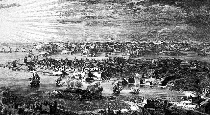
The French Invasion of 1798
Fort Manoel saw its first real combat during the French invasion of Malta in 1798. When Napoleon’s forces arrived, the fort was garrisoned by volunteer Cacciatori (chasseur light infantry) and some Birchircara militia under the Portuguese knight Gourgeau. After Grand Master Hompesch surrendered, a French garrison of several hundred men occupied Fort Manoel. The Maltese didn’t take it lying down:
- Local fighters built batteries at Għargħar and Sqaq Cappara to bombard the French inside the fort
- The Maltese attacked the fort multiple times; the French hit back with their own shelling
- On 12 September 1799, French troops from Fort Manoel tried to silence a Maltese gun position in San Ġwann — and were driven off
- When Malta became a British protectorate in 1800, the fort was officially handed over to the British military
The Maltese resilience during sieges is a recurring theme in this country’s history. For the full picture of Malta’s fortification story, Fortress Malta covers the arc from the Great Siege of 1565 to the modern period.
The Earliest Photographs of Malta
Almost nobody knows this: the earliest known photographs of Malta were taken at Fort Manoel. In 1840, the French painter Horace Vernet was quarantined at the Lazzaretto and photographed the fort’s piazza using the daguerreotype process. Those images are now believed to be lost, but the historical record confirms they existed. Standing in that same courtyard today — when it’s open — you’re in one of the first places in Malta ever captured on camera.
Bishop’s Island, l’Isolotto, and the Many Names of Manoel Island
The island has had almost as many names as it has had owners. In the early records, it was simply called l’Isolotto — “the little island.” In 1570, the Cathedral Chapter of Mdina acquired it, and it became the property of the Bishop of Malta. For the next 150 years, locals called it il-Gżira tal-Isqof (the Bishop’s Island) or l’Isola del Vescovo in Italian.
The name changed for good in the 1720s when Grand Master António Manoel de Vilhena built his fort here. Both the fort and the island were renamed after him, and “Manoel Island” stuck. The town on the mainland took its name from the Maltese word for island — Gżira — literally “the island.” So Gżira is named after the island it faces. I find that oddly satisfying.
Malta’s naming history runs deep. The Phoenicians, the Arabs, the Normans, the Knights — everyone left their mark on the language. For the broader story, the Malta history hub connects the pieces.
Frequently Asked Questions
Is Fort Manoel open to visitors?
Fort Manoel is not open on a regular daily schedule. It opens for occasional events, guided tours, and filming. The island itself is free to visit from sunrise to sunset — you can walk the coastal path, swim, and see the fort’s exterior. Check local listings for open day announcements.
How do I get to Manoel Island?
Walk to Gżira and cross the footbridge — it takes about five minutes from the Gżira waterfront. From Sliema, walk south along the harbour front for about 15 minutes. From Valletta, take the Sliema ferry and walk through Sliema towards Gżira. Buses 13, 14, and 21 run from Valletta towards the area. You can park on the island itself near the bridge — easier than Gżira street parking.
Is there an entrance fee for Manoel Island?
No. The island is free to visit. There is no ticket office or gate fee. Special events or guided tours inside Fort Manoel may have their own charges, but walking the island costs nothing.
Was Game of Thrones really filmed at Fort Manoel?
Yes. Fort Manoel was used as the Great Sept of Baelor in Game of Thrones Season 1. The execution of Ned Stark (Episode 9, “Baelor”) was filmed in the fort’s piazza. Malta was King’s Landing before production moved to Croatia for Season 2. Gladiator 2 was also recently filmed here.
Can you swim at Manoel Island?
Yes, and locals do regularly. The rocky shoreline on the south and west sides has good entry points into clear, calm water. There are no sandy beaches — it’s flat limestone rock into the sea. Bring water shoes if you’re not used to rocky entries. No lifeguard, no facilities.
Is Manoel Island becoming a national park?
Yes. In March 2026, MIDI plc formally accepted a deal to return Manoel Island and Fort Tigné to public ownership for around €43 million net. Heritage Malta is set to take possession once the final contract is signed. The government has committed to turning the island into Malta’s largest national park.
What is the Lazzaretto on Manoel Island?
A quarantine hospital built in 1643 to isolate ship passengers during plague outbreaks. Used continuously for over 200 years, expanded under the British, and later became part of the WWII submarine base HMS Talbot. The building still stands but is not regularly open to visitors.
How long should I spend on Manoel Island?
Plan 1–2 hours for a comfortable visit: the coastal walk (30–45 minutes), photos, and a swim if conditions suit. If the fort happens to be open, add another hour. The island combines well with a broader Gżira–Sliema–Valletta day.
What other Game of Thrones locations can I visit in Malta?
Quite a few. Fort St. Angelo in Birgu was the Red Keep dungeons. Mdina stood in for King’s Landing’s gates. San Anton Gardens became the Red Keep exterior. The Azure Window in Gozo (now collapsed) hosted the Dothraki wedding. Several operators offer dedicated GoT tours.
Returning to the Public — The Full Story
This is the part of the Manoel Island story that I’ve watched play out from my window in Gżira, and it matters if you’re visiting because it explains why the island looks the way it does. Here’s how it played out:
- 2000 — The Maltese government granted a 99-year concession over Manoel Island and Tigné Point to MIDI plc, a consortium of local development companies. The plan: mixed-use developments while restoring historic buildings and maintaining public access to the coastline.
- 2000–2016 — Tigné Point got its luxury apartments and shopping mall. Manoel Island got locked gates. MIDI blocked access for 16 years, in violation of the Public Domain Act.
- September 2016 — Activists from Moviment Graffitti, along with the Gżira local council led by mayor Conrad Borg Manché, physically opened the gates and camped on the island to guarantee public access. The foreshore has been open ever since.
- 2024 — MIDI submitted plans for 323 luxury apartments. Environmental NGOs flagged that the development sat entirely within a proposed UNESCO buffer zone designed to protect views of Valletta. The Planning Authority postponed its decision.
- Early 2025 — A petition gathered over 29,000 signatures — around 5% of Malta’s entire population.
- June 2025 — Government and opposition agreed the commercial development should be scrapped and Manoel Island should become a national park.
- December 2025 — A public consultation on the park’s design opened, alongside similar consultations for White Rocks and Fort Campbell.
- March 2026 — MIDI plc formally accepted a deal to return Manoel Island and Fort Tigné to public ownership for a net compensation of around €43 million. Heritage Malta is set to take possession once the final contract is signed. The island will become Malta’s largest national park.
I remember the frustration during those years when nobody could reach the island. This was one of the few open green spaces in the most densely built-up area of Malta, and it was behind locked gates. Now it’s coming back. The final contract still needs to be signed, and there are open questions about how the park will be managed and what happens to the Lazzaretto. But after 25 years of locked gates and stalled plans, the island is heading back to public hands.
If you want to follow the campaign or see the community’s vision for what the park could look like, the Manoel Island Campaign site has the petition results, an interactive map of the island, the vision document submitted to the public consultation, and a list of the 40+ organisations backing the park.
For everything else about planning your Malta trip — where to stay, what to pack, how to get around, what month to come — the Malta travel guide pulls it all together. And for help choosing a base, the honest guide to where to stay in Malta covers Gżira, Sliema, Valletta, and the alternatives.
If you visit Manoel Island at sunset, stand on the south shore and look across at Valletta. The whole fortified skyline turns gold. I’ve seen it hundreds of times and it still catches me off guard. And it’s five minutes from Gżira — you don’t even need to plan for it.
Stay in Gżira near the promenade
A designer 2-bedroom apartment in Gżira, close to the church, around 2 minutes from the promenade, and near Manoel Island.
View on Airbnb