
Why Water Matters Here · The Route · Mdina and Rabat · Chadwick Lakes · Buskett Gardens · The Wignacourt Aqueduct · Msida Washer Spring · Gozo: Fontana and San Raflu · Bonus: Alter Aqua Trail in Birgu · Practical Info · Further Reading
Why Water Matters Here
Malta has no rivers. No lakes. From May to September, it barely rains. Fly in and look down — bare limestone, pale yellow, construction cranes, not much green — and you’re looking at a place that shouldn’t have supported continuous settlement for eight thousand years.
It did because every culture that arrived had to crack the same problem from scratch. The first Neolithic settlers carved cisterns into the soft rock to trap rainwater — cisterns as old as the temple sites themselves, some dating back to around 3600 BC. Malta’s limestone is soft and easy to cut, which is one of the few geological advantages the island offers. In many cases, the stone quarried for a building’s foundations became the water reservoir underneath it — the cavity left behind was shaped into a bell, sealed, and filled from the flat roof above. You build your house and your water supply in one operation. Beneath the surface, two types of groundwater aquifer — perched aquifers in the western highlands (shallower, easier to reach, limited volume) and deeper sea-level aquifers (larger but drill too deep and you hit salt) — determined where people could settle.
The Arabs, from around 870 AD, brought qanat tunnels and gravity-fed irrigation. They sited villages near springs and wells, which is why Maltese place names are still full of Arabic: “Għajn” means spring, “Bir” means well. Farmers dug vertical shafts called spiera and used sienja — animal-driven water wheels — to lift water from depth. Over the centuries, some 42 km of underground galleries were excavated across Malta and Gozo to collect rainwater as it percolated through the rock — not a small number for islands you can drive across in under an hour.
The Knights of St. John took water storage seriously enough to make it law: when they built Valletta after the Great Siege of 1565, every building was required to have a cistern underneath. That regulation was eventually extended to cover every building on Malta, not just the capital. It was dropped in the mid-20th century — a decision that looks worse every decade as the island grows drier. The Knights also built a 15-kilometre aqueduct from the springs near Dingli to keep Valletta alive through sieges.
The British added motorised pumps, built large reservoirs with stone arches and — in some cases — early reinforced concrete, and opened Malta’s first seawater distillation plant in 1881. One British-era naval reservoir at Luqa, originally built to supply fire-fighting water to the dockyards, is so cavernous it recently hosted an orchestral concert during an open day. Today, the island runs on reverse osmosis — seawater turned to drinking water at industrial scale.
You don’t see any of this on a normal visit. That’s why this route exists.
The Route: How the Dots Connect
This isn’t a “water day.” Mdina is one of the best-preserved medieval cities in Europe. Chadwick Lakes is a proper valley walk — enclosed, shaded, nothing like the exposed coastline everywhere else. Buskett is the closest thing to a Mediterranean forest on Malta, with a castle in the middle. The Wignacourt Aqueduct is something you’ll drive past on the way back, and if nobody told you to look for it, you’d miss it. Water is the thread that connects them.
Half a day by car from anywhere in central Malta. By bus it’s doable but slower — notes under each stop. If you’re renting a car, this loop is one of the better reasons to have one.
1. Mdina and Rabat
📍 Mdina Main Gate · 📍 Saqqajja Square, Rabat
Start here. Most visitors walk Mdina’s main street, photograph the view from the bastions, and leave. The water angle gives you something else to look for.
Mdina and Rabat sit on a ridge that contains some of Malta’s most important water sources. The Romans built a qanat system under Rabat — a network of underground tunnels that moved water by gravity alone. The tunnels run between 3 and 12 metres deep, lined with rectangular shafts every 18 to 25 metres for ventilation and maintenance. They’re closed to the public, but you can see the Saqqajja Fountain at the outlet of the old system. It’s on the main square where the buses stop — you’d walk past it without knowing what it represents.
Near Mdina’s western gate there’s a spring called Għajn tal-Hasselin — a 17th-century Knights-era wash house. It’s been abandoned for years; there were warnings about potential collapse as early as 2010, and the constant water supply had eroded its foundations. Whether it was included in the 2015 restoration of the Casino Maltese next door isn’t clear. Not much to look at in its current state, but it’s right there if you’re walking the walls — and knowing what it was adds another layer to the water story.
Optional detour — Dingli spring: If you’re driving from Rabat towards Chadwick Lakes or Buskett, a short detour through Dingli takes you past another Għajn tal-Hasselin. A slippery flight of stairs between Diar il-Bniet and the church of Santa Domenica leads down to a natural spring set against a valley view. It’s the kind of spot that rewards the effort of finding it, but the steps are uneven and can be slick — proper shoes, not sandals.
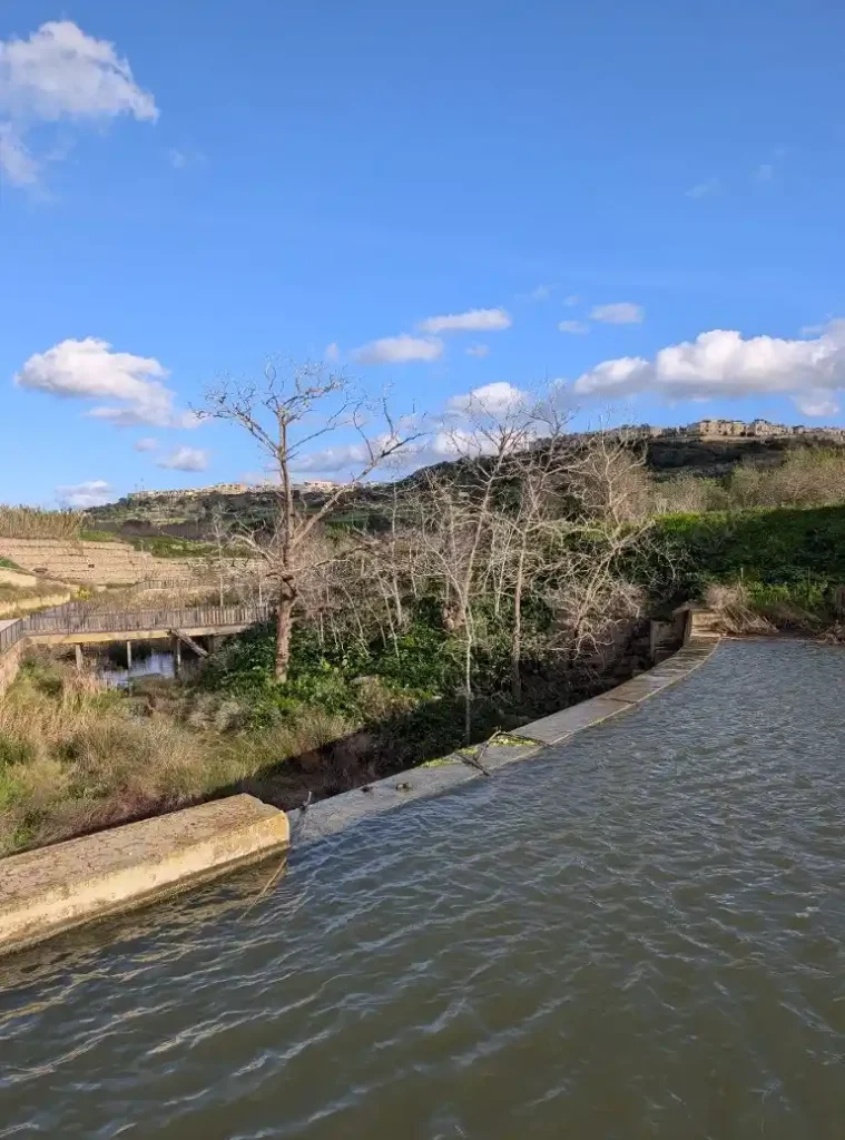
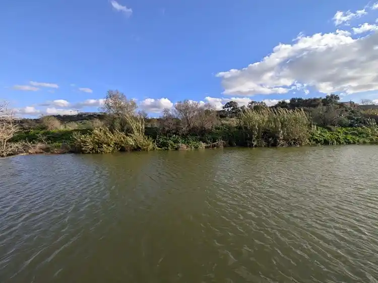
2. Chadwick Lakes
Short drive from Rabat. The official name is Wied il-Qlejgħa, but everyone calls it Chadwick Lakes after Sir Osbert Chadwick, the British engineer who designed a series of small dams here in the late 1800s to trap rainwater for the surrounding farmland.
After winter rains, the dams fill and spill between levels, and the whole area turns green. There’s a marked trail running about 2 km along the valley floor with 26 information panels. It has a distinct valley feel — enclosed, shaded by poplar and carob trees, the sound of running water — that feels completely unlike the rest of the island. Not the Lake District, but on Malta this is as close as it gets to a riparian landscape, and the contrast with the dry, exposed terrain ten minutes up the road is real.
One thing I’ve noticed in recent years: there used to be snails everywhere along this trail. They’ve largely disappeared. I don’t know if that’s a wider environmental signal or something local, but it’s the kind of change you only register if you’ve been coming here since the late nineties.
If it’s been wet enough, you might spot the qabru — Malta’s native freshwater crab. Small and shy, but the fact it exists at all on an island with no surface freshwater is part of the story. The Maltese Painted Frog (Discoglossus pictus) is also here — Malta’s only native amphibian.
If you want to extend the walk, there’s a small pond further up the valley that makes a nice loop. Quiet, usually deserted, and one of several spots where rainwater collects in the drainage system.
3. Buskett Gardens
📍 Buskett Gardens · 📍 Verdala Palace
Short drive south from Chadwick Lakes, and the contrast matters. You’ve been in a valley; now you’re in what passes for a forest on Malta.
I say “passes for” deliberately. If you’re coming from Scandinavia or the Alps, Buskett won’t match your idea of a forest. By Maltese standards, it’s extraordinary — dense pine, cypress, and citrus trees creating real shade and enclosure. The air is different. It’s cooler. You walk under a canopy for a sustained stretch, which is something you almost never do on this island.
In the middle sits Verdala Palace, the official summer residence of the President of Malta. You can’t go inside, but you can see it from the gardens. A castle in a forest on Malta — about the last thing you’d expect.
The water connection: Buskett exists because the Knights planted and irrigated it deliberately. This woodland is not natural. It was engineered as a hunting ground, and it survived because the water sources in this part of the island — the same springs that feed the aqueduct — could sustain trees that would die anywhere else on Malta. Without the water, no forest.
Buskett is also where the Maltese celebrate Imnarja — the feast of St. Peter and St. Paul, 29 June — with food, folk music, and agricultural shows. One of the island’s oldest festas. If you’re here in late June, time your visit.
4. The Wignacourt Aqueduct
📍 Aqueduct, Santa Venera · 📍 Wignacourt Arch, Fleur-de-Lys
Driving back from Buskett or Chadwick Lakes towards the coast, you pass through Attard, Balzan, and Birkirkara. Somewhere along the way, stone arches appear alongside the road. That’s the Wignacourt Aqueduct, and if you weren’t looking for it you’d drive straight past.
Built 1610–1615. Funded largely from Grand Master Wignacourt’s personal fortune — over 400,000 scudi. A 15-kilometre system carrying water from the springs near Dingli and Rabat all the way to Valletta. The underground sections worked fine until the terrain dropped at Attard. The original Jesuit engineer’s mortar wouldn’t bond to the local limestone and the water leaked through. He left Malta abruptly in 1612. A Bolognese engineer, Bontadino de Bontadini, took over, solved the waterproofing with pozzolana cement, and built the above-ground arches. Some 600 workers finished the job in four years. The system supplied roughly 1,400 cubic metres of water to Valletta daily and stayed in use until the early 20th century.
The best-preserved stretch runs along Triq il-Kbira in Santa Venera. The arches start small in Attard and get taller as the ground drops — engineering logic that makes the later sections more photogenic. At Fleur-de-Lys, a reconstructed triumphal arch (the Wignacourt Arch) marks where the aqueduct crossed the main road. The suburb got its name from the arch — the fleur-de-lis was Wignacourt’s heraldic symbol.
You don’t need long. Five minutes to walk under a few arches, notice how a 400-year-old water supply system sits in a residential street with people going about their day, and move on. But those five minutes connect everything you’ve seen — the springs, the valley, the forest — to Valletta’s survival.
Nearby: If you’re driving through Attard anyway, 📍 San Anton Gardens are worth a stop. The gardens surround the presidential palace and have several ponds with turtles, ducks, and fish — a surprising amount of freshwater for a country that has almost none. Free entry, well-shaded, and a good place to sit for twenty minutes.
And if this route has you noticing water infrastructure everywhere — good. Next time you’re in Valletta, look at the Triton Fountain at the city gate with fresh eyes. Three bronze tritons holding a basin of water above their heads, right at the entrance to a city that was built without a reliable water source. It’s a monument to the whole story.
5. Msida Washer Spring
(optional — on the way back)
If you’ve got a rental car and you’re passing through Msida, this is a two-minute stop. The Għajn tal-Ħasselin sits at 158–162 Valley Road — an 18th-century arched wash house over an older spring, at what was once the head of the Msida creek. The arched shelter was commissioned by Fra Wolfgang Philip Guttenberg in the early 1700s.
Originally used for treating cotton and hemp; later a communal laundry. Older Msida residents remember swimming in the rock-cut basin as children. The natural canal that once linked the basin to the sea was filled with war debris after WWII, and the spring gradually disappeared into urban sprawl. It was restored in 2023 with new lighting to bring out the stonework.
It’s small. It’s tucked between apartment blocks on a busy road. That’s the point — this was a village spring at the head of a creek, and now it’s a relic surrounded by traffic. The contrast says more about Malta’s transformation than most museum exhibits.
While you’re in the area: a few minutes away there’s a neglected pond off the Msida valley road, full of ducks and in a fairly miserable state. It sits, ironically, next to the headquarters of the FKNK — Malta’s hunting and conservation federation. Make of that what you will. Not a must-see, but if you’re passing and you want the unvarnished version of how Malta treats its small freshwater features, there it is.
Marsaxlokk has its own spring story, though it’s off this route: the original wash house is gone, but the village put up a statue of a man climbing out of the spring carrying wicker baskets, with two children and fish at his feet — linking the freshwater spring to the fishing village’s identity. Worth a glance if you’re there for the Sunday market anyway.
Gozo: Fontana and San Raflu
If you’re taking the ferry to Gozo, two water sites are worth knowing about. Neither justifies the crossing alone, but both fit naturally into a day on the island.
Fontana — the washer spring that still works
Fontana is a small village between Victoria and Xlendi — you drive through it on the way to the bay. The village takes its name from its springs (fontana = spring in Italian; the Maltese name, It-Triq tal-Għajn, means “the way to the spring”). The 16th-century arched wash house — l-Għajn il-Kbira — still has running water fed by stone gutters from a spring higher up in the Lunzjata Valley. The irrigation system is old enough that nobody is quite sure when it was first cut.
What makes Fontana different from the Msida or Mdina springs: people still use it. You can occasionally spot older Gozitan women there with plastic basins, hand-washing clothes in the spring water. One of those scenes that shouldn’t still exist in 2026 but does. The arched shelter, the stone troughs, the carved coat of arms — well-preserved and photogenic. A one-minute stop on the Xlendi road, no detour needed.
Għadira ta’ San Raflu — Gozo’s only permanent freshwater
Between Kerċem and the Dwejra coast, surrounded by farmland and not much else, a man-made depression collects water year-round — the only permanent freshwater body on Gozo. About 150 metres above sea level, Xlendi Bay to one side, Dwejra to the other. You can park on the surfaced road right next to it.
It has ducks, introduced goldfish and terrapins, and — more interestingly — the Maltese Painted Frog, though an alien species (Bedriaga’s Frog, introduced in the 1990s) has largely displaced it. The surrounding fields grow Calendula sicula, a Sicilian marigold found in the Maltese archipelago only here and at Xlendi.
Since 1981, the Fiera tal-Għadira has been held here on the first Sunday after Easter — an agricultural fair where farmers sell produce and livestock, with pony rides, spot prizes, live animals. Very local, not a tourist event, which is why it’s worth catching if you’re on Gozo at the right time. (Easter dates for 2026.)
On its own, it’s a quiet pond in a field. Combined with the walk to the Dwejra cliffs and the Punic temple ruins at Ras il-Wardija (about 3 km return), it becomes a half-day outing with coastal views and some properly old archaeology.
Bonus: The Alter Aqua Trail in Birgu
A different kind of water story — urban, underground, focused on one city. The Alter Aqua Reservoir Trail maps 12 underground cisterns around Birgu (Vittoriosa), some dating to the Knights’ era. You follow the route on a free web app; at each stop your phone shows what’s beneath your feet. Reservoirs that once held flood water for the docks and supplied the auberges.
Running for 13 years, funded by the Coca-Cola Foundation, developed with the University of Malta. Several reservoirs have been restored and put back into active use — the one under Victory Square now collects rainwater for the municipal water truck. National Geographic featured it in 2025. Takes about an hour.
Practical Info
- Duration: Half a day for the main Malta loop (Mdina → Chadwick Lakes → Buskett → aqueduct). Add the Msida spring on the drive back. The Gozo sites are a separate day.
- Transport: A car makes this much easier — some stops are poorly connected by bus. On public transport: bus 50, 51, 52, or 53 to Rabat (stop at Saqqajja), then 109 towards Chadwick Lakes. Getting from Chadwick Lakes to Buskett by bus is awkward; you may need to backtrack to Rabat.
- Best season: November through March. Chadwick Lakes needs rain. If you’re here in summer, skip it and do Mdina → Buskett → aqueduct. Buskett has shade year-round.
- What to bring: Water. Comfortable shoes. Sun protection even in winter. Everything is outdoors and free — no tickets, no entrance fees, no opening hours.
- Food: Eat in Rabat before or after Mdina — several decent places near Saqqajja.
The Bigger Picture
Malta today gets most of its drinking water from reverse osmosis. At one point the island had the largest RO plant in the world — an odd distinction for a country smaller than most cities. The taps don’t run dry. But the taste from the tap is chalky — a side effect of the limestone aquifers — and most people, myself included, still buy bottled. Malta also has one of the highest per-capita water consumption rates in the EU. The old problem hasn’t gone away. It just costs more energy now.
Drive this route and you see the whole arc: cisterns carved into rock thousands of years ago, Arab qanats under Rabat, a Baroque aqueduct funded by a Grand Master’s personal wealth, British-era dams in a valley, a Knights-era forest kept alive by irrigation, a communal wash house in Msida swallowed by apartment blocks, a spring in Gozo where women still do laundry by hand. Every generation’s answer to the same question. That thread is what makes a drive through the Maltese interior more than scenery.
Further Reading
If the subject gets under your skin, two books go deeper:
- “8000 Years of Water: A Maltese Story of Sustainability” (Water Services Corporation, 2022) — 500-page reference work, fifteen expert contributors, strong photography. Available from BDL Books and Agenda Bookshop. There’s also a feature-length documentary based on the book.
- “The History of Water Conservation on the Maltese Islands” by Steven Mallia (2022) — documents the reservoirs and cisterns in detail with over 500 photographs. Available from the author via the Il-Ġibjun Facebook group (2,700+ members sharing photos and research on Malta’s water heritage). Proceeds go to Puttinu Cares.
Heritage Malta runs an Underground Valletta tour covering part of the tunnel and cistern network beneath the capital — tours run on Sundays and Wednesdays, starting from the National Museum of Archaeology on Republic Street. Still limited in scope, but worth checking if it’s expanded by the time you visit. For a broader sweep of the island’s past, see our Malta history hub.
Photo Credit: Frank Vincentz
Stay in Gżira near the promenade
A designer 2-bedroom apartment in Gżira, close to the church, around 2 minutes from the promenade, and near Manoel Island.
View on Airbnb